IMAGES TAKEN NEAR TO
France Lane, WORTHING, BN13 3UP
Introduction
This page details the photographs taken nearby to France Lane, BN13 3UP by members of the Geograph project.
The Geograph project started in 2005 with the aim of publishing, organising and preserving representative images for every square kilometre of Great Britain, Ireland and the Isle of Man.

There are currently over 7.5m images from over14,400 individuals and you can help contribute to the project by visiting https://www.geograph.org.uk
Image Map
Images are licensed for reuse under creativecommons.org/licenses/by-sa/2.0
Notes
- Clicking on the map will re-center to the selected point.
- The higher the marker number, the further away the image location is from the centre of the postcode.
Image Listing (32 Images Found)
Images are licensed for reuse under creativecommons.org/licenses/by-sa/2.0
Image
Details
Distance
1
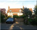
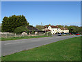
France Cottages, France Lane, Patching
Built in the latter part of the 19th century forming part of the small hamlet of France whose name may be an allusion to the distance between it and the main settlement of Patching.
Image: © Simon Carey
Taken: 28 Aug 2017
0.01 miles
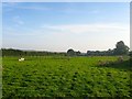
2
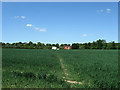
Footpath to France
A small hamlet south of Patching called France. France Cottages can be seen in the distance at the end of the field.
Image: © Simon Carey
Taken: 30 May 2009
0.04 miles
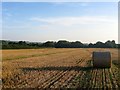
3
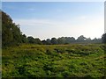
Little Dencher
The name of the field according to Patching's 1847 tithe map that is located to the south of Image, west of France Lane and east of Jewshead Wood. The building in the distance is France Barn.
Image: © Simon Carey
Taken: 28 Aug 2017
0.07 miles
4
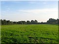
Chalcroft Field
The name of the field according to Patching's 1847 tithe map that is located to the west of Image
Image: © Simon Carey
Taken: 28 Aug 2017
0.10 miles
5
Silvester Mead Croft
The name of the field according to Patching's 1847 tithe map that is bounded by France Lane to the west and Image to the east. France Cottages are to the south.
Image: © Simon Carey
Taken: 28 Aug 2017
0.10 miles
6
France Field (2)
The name of the field according to Patching's 1847 tithe map that is bounded by Image to the north, Image to the east, and Image and Image to the west. This is the southern part, see Image for the northern section.
Image: © Simon Carey
Taken: 28 Aug 2017
0.13 miles
7
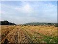
France Field (1)
The name of the field according to Patching's 1847 tithe map that is bounded by Image to the north, Image to the east and Image and Image to the west. This is the northern portion, see Image for the southern part. Clapham Wood can be seen in the distance.
Image: © Simon Carey
Taken: 28 Aug 2017
0.13 miles
8
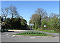
France Lane
Leading to a small settlement around a farm called France, hence the name, as well as the village of Patching. Taken from its junction with Arundel Road, the former A27.
Image: © Simon Carey
Taken: 13 Apr 2009
0.13 miles
9
The Worlds End, Arundel Road
Old coaching inn dating back to the 18th century when it was known as Patching Pond House, it became the Horse and Groom in 1847 and its current name relatively recently. Arundel Road follows the old Roman east-west route and was until recently the main A27.
Image: © Simon Carey
Taken: 13 Apr 2009
0.16 miles
10
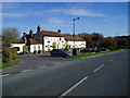
The World's End, Patching
This pub on the old A27 Arundel Road was previously called the Horse and Groom.
Image: © Peter Holmes
Taken: 12 Nov 2007
0.16 miles