IMAGES TAKEN NEAR TO
Arundel Road, WORTHING, BN13 3UJ
Introduction
This page details the photographs taken nearby to Arundel Road, BN13 3UJ by members of the Geograph project.
The Geograph project started in 2005 with the aim of publishing, organising and preserving representative images for every square kilometre of Great Britain, Ireland and the Isle of Man.

There are currently over 7.5m images from over14,400 individuals and you can help contribute to the project by visiting https://www.geograph.org.uk
Image Map
Images are licensed for reuse under creativecommons.org/licenses/by-sa/2.0
Notes
- Clicking on the map will re-center to the selected point.
- The higher the marker number, the further away the image location is from the centre of the postcode.
Image Listing (18 Images Found)
Images are licensed for reuse under creativecommons.org/licenses/by-sa/2.0
Image
Details
Distance
2
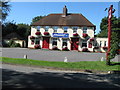
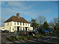
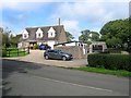
The Fox, Arundel Road
A pub has been operating here since at least 1797 though the current building dates from 1951 replacing the original which was located to its immediate west adjacent to Selden Lane.
Image: © Simon Carey
Taken: 17 Sep 2017
0.01 miles
4
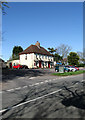
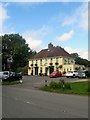
The Fox, Arundel Road
One of three in the space of a couple of miles that are on the former route of the A27. This one has a large car park and caters for dogs and riders with horses within their large garden.
Image: © Simon Carey
Taken: 13 Apr 2009
0.02 miles
5
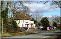
The Fox Public House
Situated in the North of this grid square close to the A27.
Image: © Chris Shaw
Taken: 14 Dec 2003
0.02 miles
6
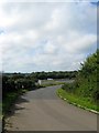
Access road to Patching
Linking the A249 with Arundel Road
Image: © David Howard
Taken: 23 Jun 2018
0.06 miles
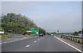
7
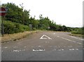
A27 Slip Road
For eastbound traffic only, linking the current A27 to Arundel Road, the former course of the A27. Poling Furzefields is the wood in the distance.
Image: © Simon Carey
Taken: 17 Sep 2017
0.08 miles
8
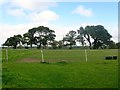
Jennings Croft
The name of the field according to Patching's 1847 tithe map which is bounded by Arundel Road to the south, Image to the west and Image to the north east.
Image: © Simon Carey
Taken: 17 Sep 2017
0.08 miles
10
Foxhill Cottage, Arundel Road
The flint wall on the right suggests, as do older maps, that this was once the site of a set of farm outbuildings. The cottage itself dates from around the 1960s and also appears to have replaced something older.
Image: © Simon Carey
Taken: 17 Sep 2017
0.15 miles