IMAGES TAKEN NEAR TO
Arundel Road, WORTHING, BN13 3UF
Introduction
This page details the photographs taken nearby to Arundel Road, BN13 3UF by members of the Geograph project.
The Geograph project started in 2005 with the aim of publishing, organising and preserving representative images for every square kilometre of Great Britain, Ireland and the Isle of Man.

There are currently over 7.5m images from over14,400 individuals and you can help contribute to the project by visiting https://www.geograph.org.uk
Image Map
Images are licensed for reuse under creativecommons.org/licenses/by-sa/2.0
Notes
- Clicking on the map will re-center to the selected point.
- The higher the marker number, the further away the image location is from the centre of the postcode.
Image Listing (20 Images Found)
Images are licensed for reuse under creativecommons.org/licenses/by-sa/2.0
Image
Details
Distance
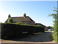
2
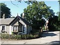
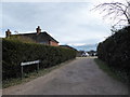
Worthing Lodge
Also known as Castle Goring Lodge having been located on the old course of Arundel Road at the entrance for the house of the same name. The dwelling dates from around 1830. Number 14 Castle Goring Cottage is just visible through the trees and is one of a number of dwellings that cluster around the entrance to Castle Goring.
Image: © Simon Carey
Taken: 20 Jul 2013
0.08 miles
3
Cottage on the southern side of the A27 dual carriageway
Possibly a gate lodge for Castle Goring House.
Image: © Dave Spicer
Taken: 5 Oct 2011
0.09 miles
4
Looking westwards towards Worthing Lodge
Image: © Basher Eyre
Taken: 28 Feb 2016
0.09 miles
6
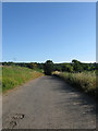
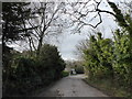
Holt Lane
A private lane providing access to the outbuildings of Holt Farm plus a couple of other dwellings which are all that remains of the medieval hamlet of Holt. The lane is also a public bridleway which heads north to Clapham Wood and Church Hill.
Image: © Simon Carey
Taken: 20 Jul 2013
0.13 miles
7
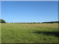
Holt Rough/Holt Parks
The name of two former woods that once covered these fields. Holt Rough was in the foreground and lay on what was once a former piece of common land whilst Holt Parks was beyond the dip to the right and was called Park Wood in Clapham's 1843 tithe map. Both woods were grubbed sometime in the 1960s. Clapham Wood can be seen in the distance to the right.
Image: © Simon Carey
Taken: 20 Jul 2013
0.13 miles
9
Castle Goring Mews
A housing development made up of former associated buildings of nearby Castle Goring. Amongst the various buildings converted into dwellings are a former stable block.
Image: © Simon Carey
Taken: 20 Jul 2013
0.14 miles
10
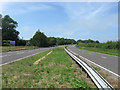
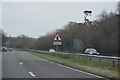
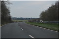
Arundel Road
The current A27 though the route itself is much older roughly following the line of the old Roman east-west road. The road was dualled from Worthing to Clapham during the 1960s.
Image: © Simon Carey
Taken: 30 Jun 2013
0.15 miles