IMAGES TAKEN NEAR TO
Arundel Road, WORTHING, BN13 3UB
Introduction
This page details the photographs taken nearby to Arundel Road, BN13 3UB by members of the Geograph project.
The Geograph project started in 2005 with the aim of publishing, organising and preserving representative images for every square kilometre of Great Britain, Ireland and the Isle of Man.

There are currently over 7.5m images from over14,400 individuals and you can help contribute to the project by visiting https://www.geograph.org.uk
Image Map
Images are licensed for reuse under creativecommons.org/licenses/by-sa/2.0
Notes
- Clicking on the map will re-center to the selected point.
- The higher the marker number, the further away the image location is from the centre of the postcode.
Image Listing (6 Images Found)
Images are licensed for reuse under creativecommons.org/licenses/by-sa/2.0
Image
Details
Distance
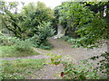
1
Path junction by Cote Nurseries
The Restricted Byway continues to Honeysuckle Lane on West Hill and the footpath to Cote Bottom.
Image: © Dave Spicer
Taken: 5 Oct 2011
0.19 miles
2
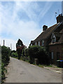
Cottages, Cote Street, Cote
Dating from the 19th century and located towards the northern end of Cote Street. Cote was originally a small hamlet that was part of Durrington parish until that was transferred to Worthing borough council in 1929.
Image: © Simon Carey
Taken: 30 Jun 2013
0.20 miles
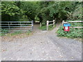
3
Cote Street northbound to Cote Nurseries
Image: © Dave Spicer
Taken: 5 Oct 2011
0.20 miles
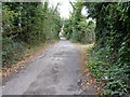
4
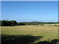
The Kiln Field/Barn Field
The name of the field according to Durrington's 1839 tithe map viewed from Cote Street. The Kiln Field was in the foreground whilst Barn Field lay adjacent to the modern day A27 further down the slope. The fence on the right marks the parish boundary between Clapham and Durrington later Worthing borough. Highdole Hill is visible in the distance above Goring Wood.
Image: © Simon Carey
Taken: 20 Jul 2013
0.21 miles
5
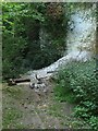
Old Chalk Pit, Cote Bottom
This is the southern end of the pit that lies next to the junction of the byway and footpath at the end of Cote Street. The pit was marked as such on Durrington's 1839 tithe map though it was called the old chalk pit on the 1875 OS map suggesting quarrying had since ended. Some alfresco drinking seems to have gone on here the night before as the fire was still smoldering around 9am for the following morning.
Image: © Simon Carey
Taken: 20 Jul 2013
0.24 miles