IMAGES TAKEN NEAR TO
Shetland Court, WORTHING, BN13 3RL
Introduction
This page details the photographs taken nearby to Shetland Court, BN13 3RL by members of the Geograph project.
The Geograph project started in 2005 with the aim of publishing, organising and preserving representative images for every square kilometre of Great Britain, Ireland and the Isle of Man.

There are currently over 7.5m images from over14,400 individuals and you can help contribute to the project by visiting https://www.geograph.org.uk
Image Map
Images are licensed for reuse under creativecommons.org/licenses/by-sa/2.0
Notes
- Clicking on the map will re-center to the selected point.
- The higher the marker number, the further away the image location is from the centre of the postcode.
Image Listing (19 Images Found)
Images are licensed for reuse under creativecommons.org/licenses/by-sa/2.0
Image
Details
Distance
1

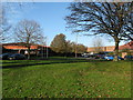
Laurels First School
First school for students aged 4 to 8 in West Durrington. Opened in 1987.
Image: © WorthingMan
Taken: 15 Feb 2009
0.05 miles
2
Faraday Close West Durrington
A small industrial site amongst residential housing. By coincident or not, one of the companies on the site is Eurotherm, of which one of their products is AC and DC drives.
Image: © Dave Spicer
Taken: 3 Dec 2012
0.15 miles
3
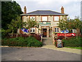
The Farmhouse, Fulbeck Avenue, Worthing
Period farmhouse and barn converted in 2002 into a public house.
Image: © Peter Holmes
Taken: 15 Oct 2007
0.15 miles
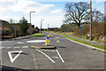
4
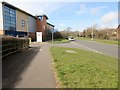
End of cycle route, Romany Road, BN13 3DL
Public footpath 3114 adjacent to David Lloyd fitness club.
Image: © Peter Holmes
Taken: 6 Mar 2015
0.18 miles
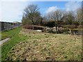
5
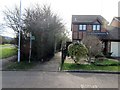
Batemans Close, BN13 3SA
Public footpath 3114.
Image: © Peter Holmes
Taken: 6 Mar 2015
0.18 miles
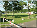
6
Fulbeck Avenue - Varey Road junction, 2010
Looking from part of Fulbeck Avenue which was then only a stub, awaiting northwards development.
Image: © Robin Webster
Taken: 4 Mar 2010
0.20 miles
7
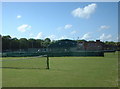
West Worthing Tennis & Squash Club
Close to Titnore Lane and the ancient (and threatened) woodland to the west of Worthing.
Image: © Chris Shaw
Taken: 15 Jun 2005
0.20 miles
8
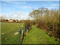
Footpath adjacent to Playing Field
Public footpath 3114.
Image: © Peter Holmes
Taken: 6 Mar 2015
0.20 miles
9
Caravan Club Site at Titnore Lane, Worthing
An attractive caravan site situated close to Worthing and Goring-by-Sea.
Image: © Derek Bradley
Taken: 9 Jul 2005
0.21 miles
10
Footpath by Northbrook Pond (West Durrington)
Public footpath 3114. The scrub areas around the pond are coppiced by Worthing Conservation Volunteers to maintain its value to wildlife and provide cover for nesting aquatic birds.
Image: © Peter Holmes
Taken: 6 Mar 2015
0.22 miles