IMAGES TAKEN NEAR TO
Loddon Close, WORTHING, BN13 3LU
Introduction
This page details the photographs taken nearby to Loddon Close, BN13 3LU by members of the Geograph project.
The Geograph project started in 2005 with the aim of publishing, organising and preserving representative images for every square kilometre of Great Britain, Ireland and the Isle of Man.

There are currently over 7.5m images from over14,400 individuals and you can help contribute to the project by visiting https://www.geograph.org.uk
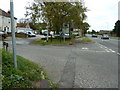
Image Map
Images are licensed for reuse under creativecommons.org/licenses/by-sa/2.0
Notes
- Clicking on the map will re-center to the selected point.
- The higher the marker number, the further away the image location is from the centre of the postcode.
Image Listing (19 Images Found)
Images are licensed for reuse under creativecommons.org/licenses/by-sa/2.0
Image
Details
Distance
3
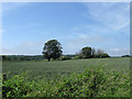
Little East House
The name of the field according to Clapham's 1843 tithe map and marking the eastern end of the parish next to the boundary with the borough of Worthing.
Image: © Simon Carey
Taken: 30 Jun 2013
0.10 miles
4

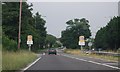
Arundel Road
The A27 as it leaves the outskirts of Worthing, the eastbound side of the road is reducing itself to one lane here as it travels through the town often causing tailbacks at peak periods. Behind the trees to the left are Image and Image on an old part of the road.
Image: © Simon Carey
Taken: 30 Jun 2013
0.10 miles
5
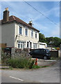
Stanhope Lodge
Built towards the end of the 18th century and lies next to Image on an old part of Image which has now been straightened and dualled.
Image: © Simon Carey
Taken: 30 Jun 2013
0.13 miles
6
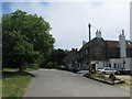
The Coach and Horses Inn
Built around 1740 as a coaching inn on the busy east-west road that is now the A27. Originally known as the Rose & Crown it had changed to its current name by the 1760s. Beyond is Image
Image: © Simon Carey
Taken: 30 Jun 2013
0.15 miles
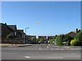
8
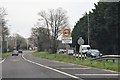
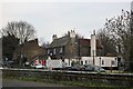
Cote Street junction with the A27
The barn like building partially hidden by the tree, was a Happy Eater restaurant several years ago.
Image: © Dave Spicer
Taken: 5 Oct 2011
0.16 miles
9
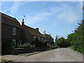
Cote Cottages, Cote
Two cottages near the junction with Arundel Road which date from the first decade of the 20th century.
Image: © Simon Carey
Taken: 30 Jun 2013
0.17 miles
10
Hollyacres, Durrington
A fairly recent development built on the site of a former waterworks and accessed only via Arundel Road, the A27.
Image: © Simon Carey
Taken: 20 Jul 2013
0.18 miles