IMAGES TAKEN NEAR TO
Church Farm Close, WORTHING, BN13 3FA
Introduction
This page details the photographs taken nearby to Church Farm Close, BN13 3FA by members of the Geograph project.
The Geograph project started in 2005 with the aim of publishing, organising and preserving representative images for every square kilometre of Great Britain, Ireland and the Isle of Man.

There are currently over 7.5m images from over14,400 individuals and you can help contribute to the project by visiting https://www.geograph.org.uk
Image Map
Images are licensed for reuse under creativecommons.org/licenses/by-sa/2.0
Notes
- Clicking on the map will re-center to the selected point.
- The higher the marker number, the further away the image location is from the centre of the postcode.
Image Listing (122 Images Found)
Images are licensed for reuse under creativecommons.org/licenses/by-sa/2.0
Image
Details
Distance
1
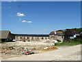
Patching Farmyard
Undergoing redevelopment, judging by aerial shots the space in the centre was previously occupied by barns.
Image: © Simon Carey
Taken: 30 May 2009
0.01 miles
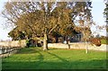
2
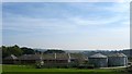
Patching Farm, Patching
Former dairy buildings built in 1844 have been converted into holiday homes in the last decade. The dairy ceased operating 1990 and the buildings became stables prior to conversion.
Image: © Simon Carey
Taken: 28 Aug 2017
0.02 miles
3
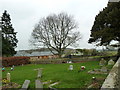
St. John the Divine, Patching: churchyard (12)
Image: © Basher Eyre
Taken: 1 Mar 2011
0.02 miles
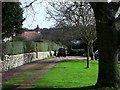
7

Patching Village
Looking towards Patching Church from The Street.
Image: © Chris Thomas-Atkin
Taken: 11 Feb 2019
0.03 miles
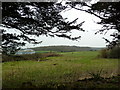
9
St. John the Divine, Patching: church path
Image: © Basher Eyre
Taken: 1 Mar 2011
0.04 miles
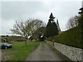
10
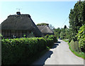
The Street
Norfolk Cottage, a 17th century building is on the left.
Image: © Simon Carey
Taken: 30 May 2009
0.04 miles