IMAGES TAKEN NEAR TO
Cleveland Copse, Cleveland Close, WORTHING, BN13 2JX
Introduction
This page details the photographs taken nearby to Cleveland Copse, Cleveland Close, BN13 2JX by members of the Geograph project.
The Geograph project started in 2005 with the aim of publishing, organising and preserving representative images for every square kilometre of Great Britain, Ireland and the Isle of Man.

There are currently over 7.5m images from over14,400 individuals and you can help contribute to the project by visiting https://www.geograph.org.uk
Image Map
Images are licensed for reuse under creativecommons.org/licenses/by-sa/2.0
Notes
- Clicking on the map will re-center to the selected point.
- The higher the marker number, the further away the image location is from the centre of the postcode.
Image Listing (13 Images Found)
Images are licensed for reuse under creativecommons.org/licenses/by-sa/2.0
Image
Details
Distance
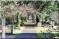
2
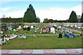
Children's Corner, Durrington cemetery
Image: © Robin Webster
Taken: 26 Feb 2010
0.11 miles
3
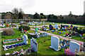
Children's Corner, Durrington cemetery
Little more need be said.
Image: © Robin Webster
Taken: 26 Feb 2010
0.12 miles
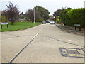
6
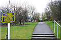
Path, Durrington Cemetery
To an ashes garden.
Image: © Robin Webster
Taken: 26 Feb 2010
0.16 miles


9
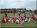
Salvington School playing fields
Popular for the boys Saturday morning football.
Image: © Chris Shaw
Taken: 20 Jul 2002
0.21 miles
10
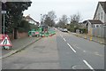
Durrington cemetery
A pleasant walk in a cemetery well-kept by Worthing borough council.
Image: © Robin Webster
Taken: 26 Feb 2010
0.21 miles