IMAGES TAKEN NEAR TO
Church Road, WORTHING, BN13 1HG
Introduction
This page details the photographs taken nearby to Church Road, BN13 1HG by members of the Geograph project.
The Geograph project started in 2005 with the aim of publishing, organising and preserving representative images for every square kilometre of Great Britain, Ireland and the Isle of Man.

There are currently over 7.5m images from over14,400 individuals and you can help contribute to the project by visiting https://www.geograph.org.uk
Image Map
Images are licensed for reuse under creativecommons.org/licenses/by-sa/2.0
Notes
- Clicking on the map will re-center to the selected point.
- The higher the marker number, the further away the image location is from the centre of the postcode.
Image Listing (132 Images Found)
Images are licensed for reuse under creativecommons.org/licenses/by-sa/2.0
Image
Details
Distance
3
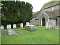
St. Andrew's, West Tarring: churchyard (2)
Image: © Basher Eyre
Taken: 2 Apr 2011
0.03 miles
4
Looking from Church Road towards St Andrew's lych gate
Image: © Basher Eyre
Taken: 2 Apr 2011
0.03 miles
5
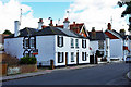
Church Cottage, Tarring
Across the road from the church.
Image: © Robin Webster
Taken: 26 Feb 2010
0.03 miles
6
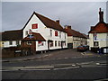
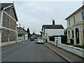
George & Dragon, High Street, Tarring
Village pub, with good selection of real ales, mentioned in Kelly's Sussex Directory of 1855.
Image: © Peter Holmes
Taken: 9 Jan 2008
0.04 miles
7
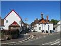
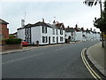
High Street, Tarring, near Worthing
High Street in Tarring, in the suburbs of Worthing.
Image: © Malc McDonald
Taken: 2 Jul 2022
0.04 miles
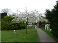
8
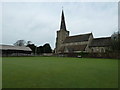
Looking across the bowling green towards St Andrew's Church
Image: © Basher Eyre
Taken: 2 Apr 2011
0.04 miles
9
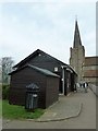
Bowls club adjacent to St Andrew's Church
Image: © Basher Eyre
Taken: 2 Apr 2011
0.04 miles
10
St. Andrew's, West Tarring: churchyard (6)
Image: © Basher Eyre
Taken: 2 Apr 2011
0.04 miles