IMAGES TAKEN NEAR TO
Castle Close, WORTHING, BN13 1BT
Introduction
This page details the photographs taken nearby to Castle Close, BN13 1BT by members of the Geograph project.
The Geograph project started in 2005 with the aim of publishing, organising and preserving representative images for every square kilometre of Great Britain, Ireland and the Isle of Man.

There are currently over 7.5m images from over14,400 individuals and you can help contribute to the project by visiting https://www.geograph.org.uk
Image Map
Images are licensed for reuse under creativecommons.org/licenses/by-sa/2.0
Notes
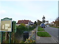
- Clicking on the map will re-center to the selected point.
- The higher the marker number, the further away the image location is from the centre of the postcode.
Image Listing (55 Images Found)
Images are licensed for reuse under creativecommons.org/licenses/by-sa/2.0
Image
Details
Distance

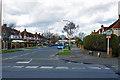
4
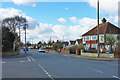
Pelham Road, West Worthing
Pelham Road is a residential road in West Worthing.
Image: © Malc McDonald
Taken: 2 Jul 2022
0.09 miles
5
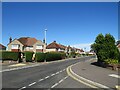
Terringes Avenue, West Worthing
Terringes Avenue is a residential road in West Worthing.
Image: © Malc McDonald
Taken: 2 Jul 2022
0.10 miles
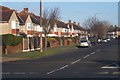
6
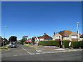
Pelham Road, south end
At the junction with Terringes Avenue.
Image: © Robin Webster
Taken: 26 Feb 2010
0.12 miles
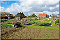
7
St Andrews Allotments - Xmas 2005
Xmas Day in Sunny Worthing!
Image: © Chris Shaw
Taken: 25 Dec 2005
0.13 miles
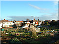
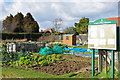
9
St Andrews Road Allotments
Remarkably surviving in the middle of a built-up area.
Image: © Robin Webster
Taken: 26 Feb 2010
0.13 miles
10
St Andrews Road Allotments
A small area.
Image: © Robin Webster
Taken: 26 Feb 2010
0.13 miles