IMAGES TAKEN NEAR TO
Canterbury Road, WORTHING, BN13 1AQ
Introduction
This page details the photographs taken nearby to Canterbury Road, BN13 1AQ by members of the Geograph project.
The Geograph project started in 2005 with the aim of publishing, organising and preserving representative images for every square kilometre of Great Britain, Ireland and the Isle of Man.

There are currently over 7.5m images from over14,400 individuals and you can help contribute to the project by visiting https://www.geograph.org.uk
Image Map
Images are licensed for reuse under creativecommons.org/licenses/by-sa/2.0
Notes
- Clicking on the map will re-center to the selected point.
- The higher the marker number, the further away the image location is from the centre of the postcode.
Image Listing (111 Images Found)
Images are licensed for reuse under creativecommons.org/licenses/by-sa/2.0
Image
Details
Distance
3
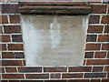
South Street Baptist Church, foundation stone (a)
Image: © Basher Eyre
Taken: 2 Apr 2011
0.04 miles
6
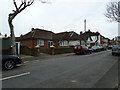
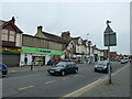
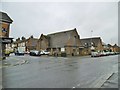
Looking from South Street into Canterbury Road
Image: © Basher Eyre
Taken: 2 Apr 2011
0.04 miles
7
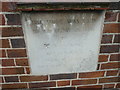
South Street Baptist Church, foundation stone (b)
Image: © Basher Eyre
Taken: 2 Apr 2011
0.04 miles
9
West Worthing Baptist Church
On South Street. https://westworthingbaptistchurch.org/
Image: © Mike Faherty
Taken: 16 Mar 2019
0.05 miles
10
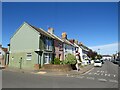
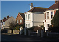
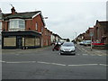
St. Dunstan's Road, West Worthing
St. Dunstan's Road is a residential street in West Worthing.
Image: © Malc McDonald
Taken: 2 Jul 2022
0.05 miles