IMAGES TAKEN NEAR TO
Cranbourne Street, BRIGHTON, BN1 2RD
Introduction
This page details the photographs taken nearby to Cranbourne Street, BN1 2RD by members of the Geograph project.
The Geograph project started in 2005 with the aim of publishing, organising and preserving representative images for every square kilometre of Great Britain, Ireland and the Isle of Man.

There are currently over 7.5m images from over14,400 individuals and you can help contribute to the project by visiting https://www.geograph.org.uk
Image Map
Images are licensed for reuse under creativecommons.org/licenses/by-sa/2.0
Notes
- Clicking on the map will re-center to the selected point.
- The higher the marker number, the further away the image location is from the centre of the postcode.
Image Listing (1403 Images Found)
Images are licensed for reuse under creativecommons.org/licenses/by-sa/2.0
Image
Details
Distance
1
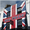
Rag Freak
Union Flag painted building.
Image: © Oast House Archive
Taken: 16 Oct 2010
0.00 miles
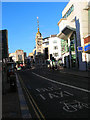
2
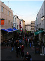
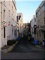
Cranbourne Street
Small pedestrianised shopping street linking Churchill Square and West Street. Originally developed in the early 1830s.
Image: © Simon Carey
Taken: 4 Nov 2007
0.01 miles
4
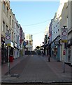
Cranbourne Street, Brighton
Pedestrianised shopping street that links West Street to Churchill Square. Developed at the turn of the 19th century.
Image: © Simon Carey
Taken: 25 Dec 2019
0.01 miles
6
The Crown's
On Cranbourne Street, Brighton. http://www.geograph.org.uk/photo/4806662
Image: © Ian S
Taken: 24 Jan 2016
0.02 miles
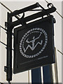
7
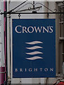
The Crown's
On Cranbourne Street, Brighton. http://www.geograph.org.uk/photo/4806660
Image: © Ian S
Taken: 24 Jan 2016
0.02 miles
8
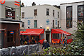
Farm Yard
A small service road whose buildings are the backs of shops which front out onto North Street (left) and Cranbourne Street (right). Taken from the pedestrianised area in front of Churchill Square its name deriving from the 18th century when there was a farm on this site.
Image: © Simon Carey
Taken: 4 Nov 2007
0.02 miles
10
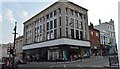
Clock Tower, Brighton
A distinctive landmark in the centre of Brighton erected in 1887 to celebrate Queen Victoria's golden jubilee. The tower is at the crossroads of the A2010 and B2066. The building on the right is Boots, which replaced a building originally built as a bank but spent its last days as the first Virgin Record shop in town with a certain R.Branson working behind the tills on occasions. This view is taken from North Street and looks west.
Image: © Simon Carey
Taken: 25 Dec 2005
0.02 miles