IMAGES TAKEN NEAR TO
Oriental Place, BRIGHTON, BN1 2LJ
Introduction
This page details the photographs taken nearby to Oriental Place, BN1 2LJ by members of the Geograph project.
The Geograph project started in 2005 with the aim of publishing, organising and preserving representative images for every square kilometre of Great Britain, Ireland and the Isle of Man.

There are currently over 7.5m images from over14,400 individuals and you can help contribute to the project by visiting https://www.geograph.org.uk
Image Map
Images are licensed for reuse under creativecommons.org/licenses/by-sa/2.0
Notes
- Clicking on the map will re-center to the selected point.
- The higher the marker number, the further away the image location is from the centre of the postcode.
Image Listing (951 Images Found)
Images are licensed for reuse under creativecommons.org/licenses/by-sa/2.0
Image
Details
Distance
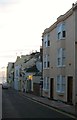
2
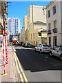
Sillwood Street
Retrace your steps westwards along the length of Gothic House then turn south down Montpelier Road and east into Sillwood Street once more, heading towards its eastern end. The view here is of the back of the old Curzon Hotel, whose engraved name can still be made out on the nearest wall but unfortunately not in the picture.
Click on the link to take you to the next page. http://www.geograph.org.uk/photo/211830
Image: © Simon Carey
Taken: 30 Jul 2006
0.02 miles
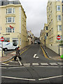
3
Oriental Place
Laid out around 1827 though original plans were to include an Oriental garden at the far end which never materialised due to lack of funds. Sillwood Hall is the building visible in the distance.
Image: © Simon Carey
Taken: 30 Oct 2011
0.02 miles
4
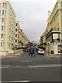
Montpelier Road
The B2122 from its junction with Kings Road, the A259. The road between this point and Western Road, the B2066, is one way only. Originally an old farm track that ran from the coast to Ditchling Road it was developed from 1820 onwards.
Image: © Simon Carey
Taken: 30 Oct 2011
0.03 miles
5
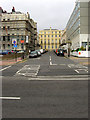
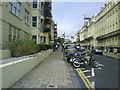
Cavendish Place
A cul-de-sac off Kings Road, the A259 developed around 1829. The building at the end of the road is the Curzon Hotel.
Image: © Simon Carey
Taken: 30 Oct 2011
0.03 miles
6
Cavendish House, Kings Road
Viewed from the Esplanade in front of the children's paddling pool and play area. Built in 1966-67 on the site of the former Union Club. To the right of it is Cavendish Place, a small cul-de-sac built in 1829 by Amon Wilds. Needless to say the block seems very out of place next to the mostly Regency buildings either side of it.
Image: © Simon Carey
Taken: 11 Jan 2009
0.04 miles
7
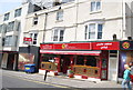
6, Montpelier Road, Brighton
Opened in 1867 as the Oriental Hotel which later became a public house called The Oriental which closed around 2007 and has since been converted into flats.
Image: © Simon Carey
Taken: 21 Nov 2015
0.04 miles
8
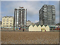
Blots on the Landscape
Cavendish House to the left and Bedford Towers, which includes the Holiday Inn to the right viewed from the shingle.
Image: © Simon Carey
Taken: 20 Feb 2009
0.04 miles
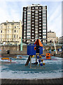
9
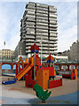
Holiday Inn
This neo-Stalinist monstrosity was opened in 1967 on the site of the former Bedford Hotel that burnt down in 1964 having been opened in 1829 and considered the best hotel in Brighton and the choice of royalty when staying in Brighton. Charles Dickens was also a 19th century guest, writing Dombey & Son during his stay. Viewed from the Esplanade with an architecturally more pleasing children's play castle in the foreground.
Image: © Simon Carey
Taken: 11 Jan 2009
0.04 miles