1
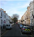
Sillwood Road, Brighton
A residential street linking Sillwood Street to Western Road. The eastern side was developed in the 1820s and was originally known as Western Terrace. To the west was a large garden that was developed in the 1870s and the road given its current name. The artist John Constable often used number 11 during his visits to the town between 1824-28.
Image: © Simon Carey
Taken: 21 Nov 2015
0.02 miles
2
Little Preston Street
At the eastern end of Sillwood Street is the junction with Little Preston Street. Running parallel with Preston Street (to the east) the street is a service road for the restaurants and businesses that are located in that street.
Click on link to take you to the next page. http://www.geograph.org.uk/photo/211834
Image: © Simon Carey
Taken: 30 Jul 2006
0.02 miles
3
Little Preston Street
Small side street linking Western Road with Kings Road mainly a service road for the restaurants and bars in Preston Street to the east.
Image: © Simon Carey
Taken: 2 Feb 2009
0.02 miles
4
Little Preston Street, Brighton
A narrow side street connecting King's Road to Western Road that was developed in the 1820s. Many, but not all, of the buildings on the eastern side are the rear of premises on Preston Street whilst further up those on the western side are the rears of buildings in Sillwood Road. The building in the foreground to the left is a private parking garage located at the rear end of Bedford Towers.
Image: © Simon Carey
Taken: 21 Nov 2015
0.03 miles
5
Gothic House, Brighton
In Western Terrace, near to Western Road, Gothic House (later known as The Priory or Priory Lodge when still in residential use) is a Gothic-style building in the centre of Brighton. Although it has been in commercial use for more than a century, it retains some of its original appearance.
Grade II listed building https://en.wikipedia.org/wiki/Gothic_House
Image: © Paul Gillett
Taken: 21 Sep 2017
0.03 miles
6
Chequers, Preston St
Image: © N Chadwick
Taken: 13 Jul 2013
0.03 miles
7
John Constable's House
at 11, Sillwood Road, the famous painter lived here 1824-26, his abode is marked with a blue plaque http://www.notableabodes.com/person-abode-details/13965/john-constable-artist_11-sillwood-road-brighton-east-sussex
Image: © Paul Gillett
Taken: 21 Sep 2017
0.04 miles
8
The Dependant, Little Preston Street
This is actually the rear entrance of the pub, the front is on Preston Street as is Medusa's. Many of the buildings on the eastern side of Little Preston Street are the backs of those on Preston Street, the former originally being a service road for the latter. The junction is with Sillwood Street.
Image: © Simon Carey
Taken: 7 May 2007
0.04 miles
9
Preston Street, Brighton
Premises on the west side.
Image: © Robin Webster
Taken: 13 Apr 2019
0.04 miles
10
The Royal Sovereign
Grade II listed. http://www.britishlistedbuildings.co.uk/en-481085-the-royal-sovereign-hotel-
Image: © N Chadwick
Taken: 13 Jul 2013
0.04 miles


