IMAGES TAKEN NEAR TO
St. Margarets Place, BRIGHTON, BN1 2FD
Introduction
This page details the photographs taken nearby to St. Margarets Place, BN1 2FD by members of the Geograph project.
The Geograph project started in 2005 with the aim of publishing, organising and preserving representative images for every square kilometre of Great Britain, Ireland and the Isle of Man.

There are currently over 7.5m images from over14,400 individuals and you can help contribute to the project by visiting https://www.geograph.org.uk
Image Map
Images are licensed for reuse under creativecommons.org/licenses/by-sa/2.0
Notes
- Clicking on the map will re-center to the selected point.
- The higher the marker number, the further away the image location is from the centre of the postcode.
Image Listing (1234 Images Found)
Images are licensed for reuse under creativecommons.org/licenses/by-sa/2.0
Image
Details
Distance
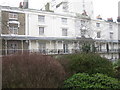
1
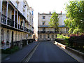
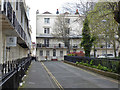
Russell Square
Turn south out of Clarence Square and you reach Russell Square. The southern and western sides were developed by Amon Henry Wilds from 1825. The small footpath between the western and southern terraces takes you to the Regency Tavern and Regency Square beyond. The southern side of the square is home to three hotels whilst the northern and western sides are now either bed & breakfasts or flats.
Click on the link to take you to the next page. http://www.geograph.org.uk/photo/211928
Image: © Simon Carey
Taken: 30 Jul 2006
0.02 miles
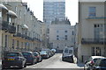
2
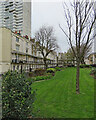
Brighton: Russell Square
Regency terraces of 1820 dwarfed by a tower block.
Image: © John Sutton
Taken: 8 Apr 2022
0.02 miles
3
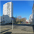
Brighton: Russell Square contrast
A modest Regency square of 1820, dominated by the Sussex Heights tower block.
Image: © John Sutton
Taken: 9 Apr 2022
0.02 miles
4
Russell Square
A view of the listed southern side from the small alley that links this square with Regency Square. The square was built during the 1820s by A H Wilds who built a number of buildings in Brighton during this period of expansion. Until the 1960s the far eastern side would have been filled with houses of a similar design but these were swept away as part of the massive Churchill Square redevelopment which also included two large tower blocks, one of which, Chartwell House, can be seen above the multi-storey car park.
Image: © Simon Carey
Taken: 25 Jan 2014
0.02 miles
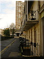
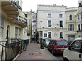
5
Russell Square, Brighton
Properties along southern side of square.
Image: © Rib
Taken: 18 Jan 2010
0.02 miles
6
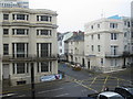
Junction of Cannon Place (foreground) and St Margaret's Place
Image: © Rib
Taken: 18 Jan 2010
0.03 miles
8
The Regency Tavern, Brighton
A grade II listed building, early 19th century. A passage from Regency Square to Russell Square is to the left.
Image: © Robin Webster
Taken: 13 Apr 2019
0.03 miles
9
Russell Square, Brighton
A view along the south side. The houses and railings are grade II listed, from about 1820.
Image: © Robin Webster
Taken: 13 Apr 2019
0.03 miles
10
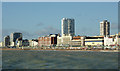
Brighton seen from the pier
This telephoto assisted image was taken from the pier about three hundred metres off-shore. Sussex Heights is the central tower block about 1100 metres away. Chartwell Court is the block on the right.
Image: © Roger D Kidd
Taken: 1 Jan 2013
0.03 miles