IMAGES TAKEN NEAR TO
Coleridge Crescent, WORTHING, BN12 6LT
Introduction
This page details the photographs taken nearby to Coleridge Crescent, BN12 6LT by members of the Geograph project.
The Geograph project started in 2005 with the aim of publishing, organising and preserving representative images for every square kilometre of Great Britain, Ireland and the Isle of Man.

There are currently over 7.5m images from over14,400 individuals and you can help contribute to the project by visiting https://www.geograph.org.uk
Image Map
Images are licensed for reuse under creativecommons.org/licenses/by-sa/2.0
Notes
- Clicking on the map will re-center to the selected point.
- The higher the marker number, the further away the image location is from the centre of the postcode.
Image Listing (47 Images Found)
Images are licensed for reuse under creativecommons.org/licenses/by-sa/2.0
Image
Details
Distance
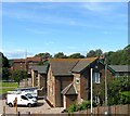
1
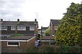
View of Durrington-on-Sea area
Taken from Highdown Hotel just below the viewpoint parking area, this view covers the area of Durrington on Sea in this grid square, with Goring-by-Sea in the distance. The picture was taken looking directly southeast, diagonally across the square.
Image: © Pam Brophy
Taken: 15 Apr 2005
0.05 miles
2

Goring-by-Sea, path
Footpath and cycle route next to Goring Street, heading towards Goring Crossway.
Image: © Mike Faherty
Taken: 23 Feb 2019
0.09 miles
3
May Bridge, Goring Street, Goring
Taking the A259 over Ferring Rife. The flats on the right are part of Goring Chase whilst in the distance is Image
Image: © Simon Carey
Taken: 13 Aug 2017
0.10 miles
4

Goring-by-Sea, Ferring Rife
Ditch draining into the Channel at Ferring, between fields and power lines.
Image: © Mike Faherty
Taken: 23 Feb 2019
0.12 miles
5
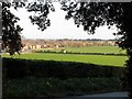
Ferring Rife
Rife is a local Sussex word for a small river found largely on the coastal plain between Worthing and Chichester. Ferring Rife rises in Durrington then heads westwards across the Goring Gap through north Ferring before heading south on the western side of the village. Here it passes between Goring Chase to the right and Lavant Close to the left.
Image: © Simon Carey
Taken: 13 Aug 2017
0.12 miles
6
Station House, Goring Street, Goring
Built in the first decade of the 20th century and, judging by old maps, erected to replace a smaller structure on the western side of the eastbound platform. Now a private dwelling.
Image: © Simon Carey
Taken: 13 Aug 2017
0.15 miles
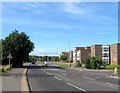
7
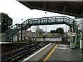
Railway Bridge, Goring-by-Sea Railway Station
Image: © Basher Eyre
Taken: 4 Dec 2010
0.15 miles
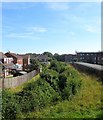
8
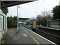
Train leaving Goring-by-Sea Railway Station for Durrington-on-Sea
Image: © Basher Eyre
Taken: 4 Dec 2010
0.15 miles
9
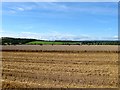
The Eight Acres/Barn Field/Lower West Field
The name of the fields according to Goring's 1839 tithe map that have been combined along with Image, Image and Image to the west to form one large field between Goring to the east, Ferring to the west, Ferring Rife to the north and the railway line to the south. The Eight Acres was in the foreground part of which was lost to the construction of the railway in 1846, Lower West Field was to the north adjacent to Ferring Rife whilst Barn Field was situated somewhere between the two. Highdown Hill provides the backdrop.
Image: © Simon Carey
Taken: 13 Aug 2017
0.15 miles