1
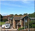
View of Durrington-on-Sea area
Taken from Highdown Hotel just below the viewpoint parking area, this view covers the area of Durrington on Sea in this grid square, with Goring-by-Sea in the distance. The picture was taken looking directly southeast, diagonally across the square.
Image: © Pam Brophy
Taken: 15 Apr 2005
0.09 miles
2
Goring-by-Sea, path
Footpath and cycle route next to Goring Street, heading towards Goring Crossway.
Image: © Mike Faherty
Taken: 23 Feb 2019
0.12 miles
3
Terraced houses, Coleridge Close
Image: © N Chadwick
Taken: 8 May 2011
0.13 miles
4
Railway Bridge, Goring-by-Sea Railway Station
Image: © Basher Eyre
Taken: 4 Dec 2010
0.14 miles
5
Train leaving Goring-by-Sea Railway Station for Durrington-on-Sea
Image: © Basher Eyre
Taken: 4 Dec 2010
0.14 miles
6
May Bridge, Goring Street, Goring
Taking the A259 over Ferring Rife. The flats on the right are part of Goring Chase whilst in the distance is
Image
Image: © Simon Carey
Taken: 13 Aug 2017
0.15 miles
7
Station House, Goring Street, Goring
Built in the first decade of the 20th century and, judging by old maps, erected to replace a smaller structure on the western side of the eastbound platform. Now a private dwelling.
Image: © Simon Carey
Taken: 13 Aug 2017
0.15 miles
8
Train leaving Goring-by-Sea station
Goring-by-Sea is an intermediate station on the West Coastway line. In this image, a Class 377 "Electrostar" train is leaving on its way to Brighton.
The railway is electrified using the third-rail system.
The bridge carries the S259 road over the railway.
Image: © Malc McDonald
Taken: 2 Jul 2022
0.15 miles
9
Goring-by-sea railway station
The station is situated between Angmering in the west and Durrington-on-Sea in the east. It is on the West Coastway Line and operated by Southern. The line was originally built for the London,Brighton & South Coast railway. Traffic on the A259 flyover can be seen to the east.
Image: © Peter Holmes
Taken: 15 Oct 2007
0.15 miles
10
Goring-by-Sea: modest car park in Station Approach
Image: © Basher Eyre
Taken: 4 Dec 2010
0.15 miles


