IMAGES TAKEN NEAR TO
Ferring Street, WORTHING, BN12 5JT
Introduction
This page details the photographs taken nearby to Ferring Street, BN12 5JT by members of the Geograph project.
The Geograph project started in 2005 with the aim of publishing, organising and preserving representative images for every square kilometre of Great Britain, Ireland and the Isle of Man.

There are currently over 7.5m images from over14,400 individuals and you can help contribute to the project by visiting https://www.geograph.org.uk
Image Map
Images are licensed for reuse under creativecommons.org/licenses/by-sa/2.0
Notes
- Clicking on the map will re-center to the selected point.
- The higher the marker number, the further away the image location is from the centre of the postcode.
Image Listing (97 Images Found)
Images are licensed for reuse under creativecommons.org/licenses/by-sa/2.0
Image
Details
Distance
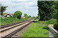
2
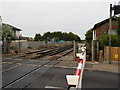
Ferring, level crossing
Carrying Ferring Street across the Brighton to Portsmouth/Southampton railway lines.
Image: © Mike Faherty
Taken: 9 Mar 2019
0.01 miles
3
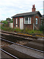
Former Level Crossing Keeper's Cottage
Next to where the West Coastway line crosses Ferring Street. Typical of a number that once existed along this line.
Image: © Simon Carey
Taken: 20 Jul 2008
0.01 miles
5
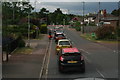
A slow ride home: 7 hours on buses and overtaken by touring bikes in Ferring
Having abandoned the aeroplane at Goodwood after a 2 hour trip (205 miles by road) from North Lincs, it took 7 hours on the bus to travel the 35 miles from Bognor to Peacehaven and back.
We limped along with the two bikes for company for several miles.
Image: © Chris
Taken: 11 Jun 2016
0.01 miles
6
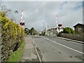
Brighton to Littlehampton Junction line, BLI1
Looking towards Brighton from the footpath 2113 crossing. Traffic was suspended for Sunday engineering work, the most obvious from this location being work on the Ferring level crossing, seen round the bend.
Image: © Robin Webster
Taken: 20 Jun 2010
0.01 miles
7
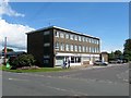
1-7, Elm Park, Ferring
A small row of shops with maisonettes above that was built in the 1960. Number 1 contains the local parish council offices.
Image: © Simon Carey
Taken: 6 Aug 2017
0.02 miles
8
The Henty Arms
Just by the railway in Ferring Street
Image: © Josie Campbell
Taken: 26 Jul 2011
0.02 miles
9

Ferring, council office
On Ferring Street/Elm Grove, the office of Ferring Parish Council (with the green blinds): https://www.ferringparishcouncil.org.uk/about/ferring-parish-council/
Image: © Mike Faherty
Taken: 9 Mar 2019
0.02 miles
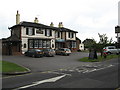
10
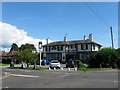
Henty Arms, Ferring Lane, Ferring
Built in 1830 on the junction of Ferring Lane and Langbury Lane, the two routes into the old village centre, and thus predating the railway by at least a decade. Originally known as the New Inn it acquired its current name in 1927 when run by brewers Henty and Constable, Henty also being the name of the main local landowners.
Image: © Simon Carey
Taken: 6 Aug 2017
0.02 miles