IMAGES TAKEN NEAR TO
Ferring Street, WORTHING, BN12 5JS
Introduction
This page details the photographs taken nearby to Ferring Street, BN12 5JS by members of the Geograph project.
The Geograph project started in 2005 with the aim of publishing, organising and preserving representative images for every square kilometre of Great Britain, Ireland and the Isle of Man.

There are currently over 7.5m images from over14,400 individuals and you can help contribute to the project by visiting https://www.geograph.org.uk
Image Map
Images are licensed for reuse under creativecommons.org/licenses/by-sa/2.0
Notes
- Clicking on the map will re-center to the selected point.
- The higher the marker number, the further away the image location is from the centre of the postcode.
Image Listing (115 Images Found)
Images are licensed for reuse under creativecommons.org/licenses/by-sa/2.0
Image
Details
Distance
1
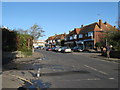
Parade of shops on Ferring Street Ferring
Image: © Dave Spicer
Taken: 14 Nov 2012
0.01 miles
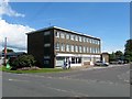
2

Onslow Parade, Ferring Street, Ferring
A parade of shops built in the 1950s. Beyond is Image
Image: © Simon Carey
Taken: 6 Aug 2017
0.02 miles
3

Shops on Singleton Crescent, Ferring
The railway runs behind it
Image: © David Howard
Taken: 23 Jun 2018
0.04 miles
4
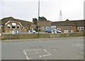
Ferring Village Hall
On Ferring Street: http://www.ferringvillagehall.org.uk/
Image: © Mike Faherty
Taken: 9 Mar 2019
0.04 miles
5

Onslow Parade, Ferring Street
Between the village hall and level crossing are another parade of shops the most northerly in the village. The flats in the distance mark the junction with Elm Park which is actually in the next square.
Image: © Simon Carey
Taken: 20 Jul 2008
0.04 miles
6

Ferring, council office
On Ferring Street/Elm Grove, the office of Ferring Parish Council (with the green blinds): https://www.ferringparishcouncil.org.uk/about/ferring-parish-council/
Image: © Mike Faherty
Taken: 9 Mar 2019
0.04 miles
7
1-7, Elm Park, Ferring
A small row of shops with maisonettes above that was built in the 1960. Number 1 contains the local parish council offices.
Image: © Simon Carey
Taken: 6 Aug 2017
0.04 miles
8
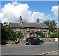
35-37, Ferring Street, Ferring
Two flint cottages built in the early 19th century marking the northern point of the original settlement. Number 35 is also known as Vine Cottage whilst 37 is Landells.
Image: © Simon Carey
Taken: 6 Aug 2017
0.05 miles
9
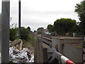
The railway line at Ferring
By the level crossing
Image: © David Howard
Taken: 23 Jun 2018
0.05 miles
10

Ferring, post office & store
Co-op Food and post office, on Ferring Street.
Image: © Mike Faherty
Taken: 9 Mar 2019
0.05 miles