IMAGES TAKEN NEAR TO
Greenways Crescent, WORTHING, BN12 5EF
Introduction
This page details the photographs taken nearby to Greenways Crescent, BN12 5EF by members of the Geograph project.
The Geograph project started in 2005 with the aim of publishing, organising and preserving representative images for every square kilometre of Great Britain, Ireland and the Isle of Man.

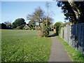
There are currently over 7.5m images from over14,400 individuals and you can help contribute to the project by visiting https://www.geograph.org.uk
Image Map
Images are licensed for reuse under creativecommons.org/licenses/by-sa/2.0
Notes
- Clicking on the map will re-center to the selected point.
- The higher the marker number, the further away the image location is from the centre of the postcode.
Image Listing (122 Images Found)
Images are licensed for reuse under creativecommons.org/licenses/by-sa/2.0
Image
Details
Distance
1
East Mead, Ferring
A cul de sac off Sea Lane built in the late 1950s. Partially located on a former field called Lucerne Field according to Ferring's 1837 tithe map.
Image: © Simon Carey
Taken: 6 Aug 2017
0.05 miles
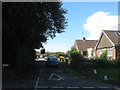
2
East Mead, BN12 5EA
Bungalows in short cul-de-sac.
Image: © Peter Holmes
Taken: 27 Jan 2017
0.06 miles
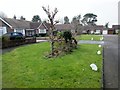
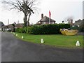
3
Sea Lane Gardens, BN12 5EG
Large conifer with heather beds frontage.
Image: © Peter Holmes
Taken: 27 Jan 2017
0.06 miles
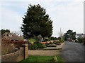
4
House with Red Ensign
Also known as the Red Duster flying in Sea Lane Gardens BN12 5EQ.
Image: © Peter Holmes
Taken: 27 Jan 2017
0.06 miles
5
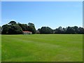
Little Twitten Recreation Ground, Ferring
Once known as Street Field according to Ferring's 1837 tithe map it became a public open space in the 1950s and is located between Ferring Street and Sea Lane. Since the 1950s it has also been home to Ferring Cricket Club whose current pavilion was built in 1994 replacing a much older former railway carriage that moved with the club when they changed grounds. The carriage was later donated to the Bluebell Railway.
Image: © Simon Carey
Taken: 6 Aug 2017
0.07 miles
6
Grange Close
Much of Ferring is now bungalows which were developed from the 1920s onwards and are indicative of much of the development between Worthing and Bognor. Taken from the junction with Grange Park.
Image: © Simon Carey
Taken: 20 Jul 2008
0.07 miles
7
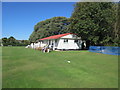
Ferring Cricket Pavilion
Teams retire to the pavilion for tea. http://www.ferringcricket.co.uk/
Image: © Peter Holmes
Taken: 11 Sep 2016
0.09 miles
8
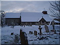
St Andrew's Church Ferring
The north side of St Andrew's in Church Lane viewed on a winter's morning.
Image: © Peter Holmes
Taken: 24 Jan 2007
0.11 miles
9
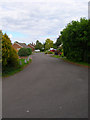
Public Footpath 2119
Linking Sea Lane with Church Lane the path adjoins Ferring Cricket Club ground.
Image: © Peter Holmes
Taken: 14 Mar 2010
0.11 miles
10
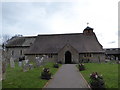
St Andrew, Ferring: late February 2016
Image: © Basher Eyre
Taken: 28 Feb 2016
0.12 miles