IMAGES TAKEN NEAR TO
Singleton Crescent, WORTHING, BN12 5DQ
Introduction
This page details the photographs taken nearby to Singleton Crescent, BN12 5DQ by members of the Geograph project.
The Geograph project started in 2005 with the aim of publishing, organising and preserving representative images for every square kilometre of Great Britain, Ireland and the Isle of Man.

There are currently over 7.5m images from over14,400 individuals and you can help contribute to the project by visiting https://www.geograph.org.uk
Image Map
Images are licensed for reuse under creativecommons.org/licenses/by-sa/2.0
Notes
- Clicking on the map will re-center to the selected point.
- The higher the marker number, the further away the image location is from the centre of the postcode.
Image Listing (26 Images Found)
Images are licensed for reuse under creativecommons.org/licenses/by-sa/2.0
Image
Details
Distance
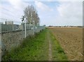
1
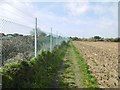
Goring-by-Sea, footpath
From Goring Street to Ferring Street, between railway lines and farmland.
Image: © Mike Faherty
Taken: 9 Mar 2019
0.07 miles
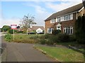
2
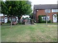
Twitten linking north and south sections of Singleton Crescent
Semi-detached properties in Singleton Crescent BN12 5DJ.
Image: © Peter Holmes
Taken: 22 Aug 2016
0.09 miles
3
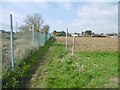
Goring-by-Sea, path junction
Ahead, to Ferring Street; right, to Ferring Lane. The path to the right also forms the boundary between Goring and Ferring.
Image: © Mike Faherty
Taken: 9 Mar 2019
0.11 miles
4
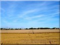
The Shorts
The name of the field according to Goring's 1839 tithe map that has been combined with Image and Image to the east and Image to the north to make a large field that is bounded by the settlements of Ferring and Goring to the west and east respectively, the railway line to the south and Ferring Rife to the north. To the west is Image
The narrow gap between the two settlements is still used for agricultural purposes though the land has been owned by Persimmon Homes for some time suggesting that some time in the future it will probably be developed.
Image: © Simon Carey
Taken: 13 Aug 2017
0.12 miles
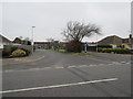
5
Singleton Crescent, BN12 5DA
Semi-detached properties on corner with Westergate Close.
Image: © Peter Holmes
Taken: 22 Aug 2016
0.12 miles
6
Short dual carriageway
Road junction between Goring Way and Singleton Crescent.
Image: © Peter Holmes
Taken: 19 Mar 2015
0.14 miles
7
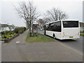
Compass bus in Goring Way
Route 8 to Worthing. Also stop for 700 Stagecoach bus to Brighton.
Image: © Peter Holmes
Taken: 19 Mar 2015
0.14 miles
9
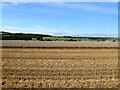
The Nineteen Acres/The In Close/Upper West Field
The name of the fields according to Goring's 1839 tithe map that have been combined, along with Image to the east, Image to the west and Image to the north west to form a much larger field that covers the area bounded by the railway line to the south, Ferring Rife to the north and the settlements of ferring and Goring to the west and east respectively.
Image: © Simon Carey
Taken: 13 Aug 2017
0.18 miles
10
Goring-by-Sea, footpath
From Goring Street to Ferring Street, between railway lines and farmland.
Image: © Mike Faherty
Taken: 9 Mar 2019
0.19 miles