IMAGES TAKEN NEAR TO
Mersham Gardens, WORTHING, BN12 4TQ
Introduction
This page details the photographs taken nearby to Mersham Gardens, BN12 4TQ by members of the Geograph project.
The Geograph project started in 2005 with the aim of publishing, organising and preserving representative images for every square kilometre of Great Britain, Ireland and the Isle of Man.

There are currently over 7.5m images from over14,400 individuals and you can help contribute to the project by visiting https://www.geograph.org.uk
Image Map
Images are licensed for reuse under creativecommons.org/licenses/by-sa/2.0
Notes
- Clicking on the map will re-center to the selected point.
- The higher the marker number, the further away the image location is from the centre of the postcode.
Image Listing (130 Images Found)
Images are licensed for reuse under creativecommons.org/licenses/by-sa/2.0
Image
Details
Distance
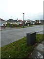
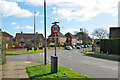
1
St Mary's spire as seen from Compton Avenue
Image: © Basher Eyre
Taken: 4 Dec 2010
0.07 miles
3
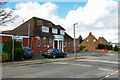
Goring Conservative Club
The lamp-post has a Conservative tendency!
Image: © Robin Webster
Taken: 26 Feb 2010
0.07 miles
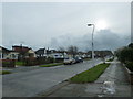
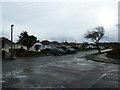
5
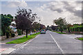
Compton Avenue
Suburban road south of Goring Way.
Image: © Ian Capper
Taken: 26 Oct 2021
0.08 miles
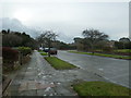
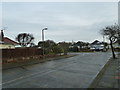
6
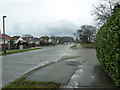
Approaching the junction of Wadhurst Drive and Compton Avenue
Image: © Basher Eyre
Taken: 4 Dec 2010
0.08 miles
7
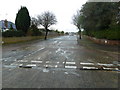
Looking from Compton Avenue into Wadhurst Drive
Image: © Basher Eyre
Taken: 4 Dec 2010
0.09 miles
8
Looking from Crowborough Drive into Compton Avenue
Image: © Basher Eyre
Taken: 4 Dec 2010
0.09 miles
9
Lamppost at the eastern end of Crowborough Drive
Image: © Basher Eyre
Taken: 4 Dec 2010
0.09 miles