IMAGES TAKEN NEAR TO
Sandown Close, WORTHING, BN12 4QA
Introduction
This page details the photographs taken nearby to Sandown Close, BN12 4QA by members of the Geograph project.
The Geograph project started in 2005 with the aim of publishing, organising and preserving representative images for every square kilometre of Great Britain, Ireland and the Isle of Man.

There are currently over 7.5m images from over14,400 individuals and you can help contribute to the project by visiting https://www.geograph.org.uk
Image Map (Loading...)


Getting Data...Please wait
Leaflet Map data © OpenStreetMap
Images are licensed for reuse under creativecommons.org/licenses/by-sa/2.0
Notes
- Clicking on the map will re-center to the selected point.
- The higher the marker number, the further away the image location is from the centre of the postcode.
Image Listing (124 Images Found)
Images are licensed for reuse under creativecommons.org/licenses/by-sa/2.0
Image
Details
Distance
3

Goring-by-Sea, avenue
Holm oaks and the occasional pine, in the central reservation of Sea Lane.
Image: © Mike Faherty
Taken: 23 Feb 2019
0.06 miles
5
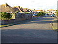
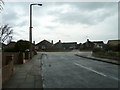
Approaching the junction of Sandown Avenue and Sandown Close
Image: © Basher Eyre
Taken: 4 Dec 2010
0.07 miles
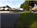
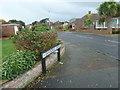
6
Looking from Sandown Avenue into Alinora Crescent
Image: © Basher Eyre
Taken: 4 Dec 2010
0.09 miles
7
Looking from Alinora Crescent into Sandown Avenue
Image: © Basher Eyre
Taken: 4 Dec 2010
0.09 miles
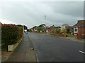
8
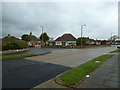
Looking across Alinora Crescent and towards Sandown Avenue
Image: © Basher Eyre
Taken: 4 Dec 2010
0.09 miles
9

Goring-by-Sea, postbox
GRVI box on the pavement on Sea Lane; ID BN12 1810D.
Image: © Mike Faherty
Taken: 23 Feb 2019
0.10 miles
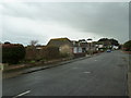
10
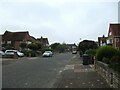
Chelwood Avenue toward Amberley Drive
Residential street in Goring by Sea
Image: © Martin Dawes
Taken: 14 May 2023
0.10 miles