IMAGES TAKEN NEAR TO
Mulberry Lane, WORTHING, BN12 4NT
Introduction
This page details the photographs taken nearby to Mulberry Lane, BN12 4NT by members of the Geograph project.
The Geograph project started in 2005 with the aim of publishing, organising and preserving representative images for every square kilometre of Great Britain, Ireland and the Isle of Man.

There are currently over 7.5m images from over14,400 individuals and you can help contribute to the project by visiting https://www.geograph.org.uk
Image Map
Images are licensed for reuse under creativecommons.org/licenses/by-sa/2.0
Notes
- Clicking on the map will re-center to the selected point.
- The higher the marker number, the further away the image location is from the centre of the postcode.
Image Listing (89 Images Found)
Images are licensed for reuse under creativecommons.org/licenses/by-sa/2.0
Image
Details
Distance
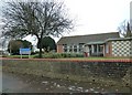
1
Goring-by-Sea CE First School
Church of England First School for students aged 4 to 8 in Goring, West Sussex. Buildings opened in 1961.
Image: © WorthingMan
Taken: 15 Feb 2009
0.02 miles
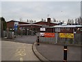
6
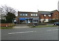
Sandwich bar and telescope shop in Mulberry Lane
Image: © Basher Eyre
Taken: 4 Dec 2010
0.06 miles
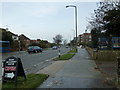
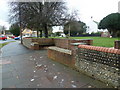
7
Looking across Mulberry Lane from the sandwich bar
The church you can see is St Mary's, Goring-by-Sea.
Image: © Basher Eyre
Taken: 4 Dec 2010
0.06 miles
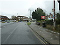
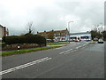
10
Looking from Mulberry Lane into Goring Way
Image: © Basher Eyre
Taken: 4 Dec 2010
0.07 miles