IMAGES TAKEN NEAR TO
Robson Road, WORTHING, BN12 4EF
Introduction
This page details the photographs taken nearby to Robson Road, BN12 4EF by members of the Geograph project.
The Geograph project started in 2005 with the aim of publishing, organising and preserving representative images for every square kilometre of Great Britain, Ireland and the Isle of Man.

There are currently over 7.5m images from over14,400 individuals and you can help contribute to the project by visiting https://www.geograph.org.uk
Image Map
Images are licensed for reuse under creativecommons.org/licenses/by-sa/2.0
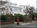
Notes
- Clicking on the map will re-center to the selected point.
- The higher the marker number, the further away the image location is from the centre of the postcode.
Image Listing (68 Images Found)
Images are licensed for reuse under creativecommons.org/licenses/by-sa/2.0
Image
Details
Distance
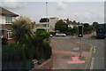
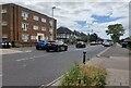
2
West Worthing, garage
Sea Place Garage, at the corner of Goring Road (A259) and Sea Place.
Image: © Mike Faherty
Taken: 23 Feb 2019
0.09 miles
4
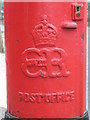
Edward VIII postbox, Robson Road / Trent Road - royal cipher
See Image
Image: © Mike Quinn
Taken: 26 Nov 2008
0.09 miles
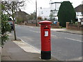
5
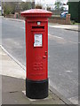
Edward VIII postbox, Robson Road / Trent Road
Image: © Mike Quinn
Taken: 26 Nov 2008
0.09 miles
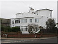
7
West Worthing, post office
On George V Avenue.
Image: © Mike Faherty
Taken: 23 Feb 2019
0.11 miles
8
Glorious yucca at the junction of Goring Road and Shaftesbury Avenue
Image: © Chris
Taken: 11 Jun 2016
0.12 miles
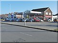
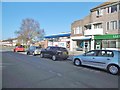
10
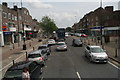
Shopping centre in Goring Road, West Worthing
Image: © Chris
Taken: 11 Jun 2016
0.13 miles