IMAGES TAKEN NEAR TO
Old Steine, BRIGHTON, BN1 1EH
Introduction
This page details the photographs taken nearby to Old Steine, BN1 1EH by members of the Geograph project.
The Geograph project started in 2005 with the aim of publishing, organising and preserving representative images for every square kilometre of Great Britain, Ireland and the Isle of Man.

There are currently over 7.5m images from over14,400 individuals and you can help contribute to the project by visiting https://www.geograph.org.uk
Image Map
Images are licensed for reuse under creativecommons.org/licenses/by-sa/2.0
Notes
- Clicking on the map will re-center to the selected point.
- The higher the marker number, the further away the image location is from the centre of the postcode.
Image Listing (2018 Images Found)
Images are licensed for reuse under creativecommons.org/licenses/by-sa/2.0
Image
Details
Distance
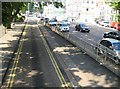
1
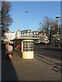
Bus Shelters, Old Steine
There are three concrete structures here that were built around 1900 for the old tram system and are currently listed. The tram service was ended in 1939 after which they served the trolley buses who themselves were taken out of service in 1961.
Image: © Simon Carey
Taken: 19 Nov 2011
0.01 miles
2
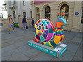
Snailspace #24 Royal Pavilion South Gate
Title: Inca Snail
Artist: Art+Bwelieve
Sponsor: Graves Son & Pilcher
Image: © Paul Gillett
Taken: 15 Sep 2018
0.01 miles
3
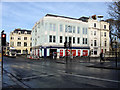
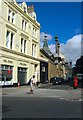
Royal Bank of Scotland, Old Steine
Originally known as Electric House and opened in 1933 as an electricity showroom. It became a bank in the 1980s and is located on the corner of the Old Steine and Castle Square with one of the domes of the Royal Pavilion viewable through the trees on the right.
Image: © Simon Carey
Taken: 11 Jan 2009
0.01 miles
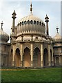
4
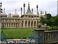
Royal Pavilion
Head north up Old Steine. The front view of the Pavilion's northern end. The section to the left is the original farmhouse. The gardens in front were originally part of the Old Steine but were enclosed by the Prince Regent in 1793 in return for constructing a sewer for the town that drained the area which included a stagnant pool to the right of the building.
Click on the link to take you to the next page. http://www.geograph.org.uk/photo/231241
Image: © Simon Carey
Taken: 1 Sep 2006
0.01 miles
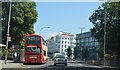
5
Brighton: Old Steine
This is the bus only lane running down the east side of the Old Steine one-way system.
Image: © Nigel Cox
Taken: 8 Jun 2008
0.01 miles
9
Palace Place, Brighton
A small cul de sac off Castle Square part of which includes the southern end of the Royal Pavilion.
Image: © Simon Carey
Taken: 20 Sep 2015
0.02 miles
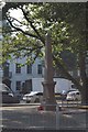
10
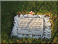
Remembering the Old Contemptibles
A stone in Brighton's garden of remembrance to the north west of Image commemorating the 'Old Contemptibles', those soldiers who were part of the army when the First World War broke out in 1914.
Image: © Simon Carey
Taken: 13 Nov 2011
0.02 miles