IMAGES TAKEN NEAR TO
Elm Grove, WORTHING, BN11 5LH
Introduction
This page details the photographs taken nearby to Elm Grove, BN11 5LH by members of the Geograph project.
The Geograph project started in 2005 with the aim of publishing, organising and preserving representative images for every square kilometre of Great Britain, Ireland and the Isle of Man.

There are currently over 7.5m images from over14,400 individuals and you can help contribute to the project by visiting https://www.geograph.org.uk
Image Map
Images are licensed for reuse under creativecommons.org/licenses/by-sa/2.0
Notes
- Clicking on the map will re-center to the selected point.
- The higher the marker number, the further away the image location is from the centre of the postcode.
Image Listing (47 Images Found)
Images are licensed for reuse under creativecommons.org/licenses/by-sa/2.0
Image
Details
Distance
1

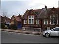
West Worthing, primary school
Elm Grove Primary School. The building dates from 1905. https://elmgrove.org.uk/wsussex/primary/elmgrove
Image: © Mike Faherty
Taken: 23 Feb 2019
0.06 miles
2
Elm Grove First School
First School for students aged 4 to 8 in West Worthing. Originally opened in 1905 as a mixed and infants school. Became first school in 1977.
Image: © WorthingMan
Taken: 15 Feb 2009
0.06 miles
3
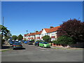
Ripley Road, West Worthing
Ripley Road is a residential road in West Worthing.
Image: © Malc McDonald
Taken: 2 Jul 2022
0.09 miles
4
Ripley Road, West Worthing
Ripley Road is a residential road in West Worthing. The building closest to the camera is an evangelical church.
Image: © Malc McDonald
Taken: 2 Jul 2022
0.09 miles
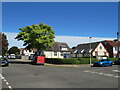
5
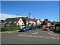
Rugby Road, West Worthing
Rugby Road is a residential road in West Worthing.
Image: © Malc McDonald
Taken: 2 Jul 2022
0.10 miles
6

West Worthing, footbridge
Taking pedestrians over railway lines from Tarring Road to Canterbury Road.
Image: © Mike Faherty
Taken: 23 Feb 2019
0.10 miles
7
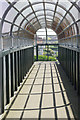
Footbridge to Tarring Road
Providing pedestrians with a route across the railway between West Worthing and Durrington on Sea stations. The bridge is well protected preventing miscreants throwing anything onto the railway below.
Image: © Stephen McKay
Taken: 1 Jun 2017
0.10 miles
8
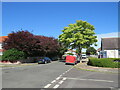
West Worthing Evangelical Church
West Worthing Evangelical Church is located on the corner of two residential roads, Ripley Road and Rugby Road, in West Worthing.
Image: © Malc McDonald
Taken: 2 Jul 2022
0.10 miles
9
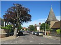
Ripley Road, West Worthing
Ripley Road is a residential road in West Worthing. The church of St. John the Divine stands to the right
Image: © Malc McDonald
Taken: 2 Jul 2022
0.11 miles
10
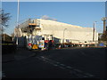
Refurbishment of footbridge over the Brighton to Portsmouth line
During the closure a temporary bridge has been erected.
Image: © Dave Spicer
Taken: 29 Nov 2012
0.11 miles