IMAGES TAKEN NEAR TO
Langham Gardens, WORTHING, BN11 5BN
Introduction
This page details the photographs taken nearby to Langham Gardens, BN11 5BN by members of the Geograph project.
The Geograph project started in 2005 with the aim of publishing, organising and preserving representative images for every square kilometre of Great Britain, Ireland and the Isle of Man.

There are currently over 7.5m images from over14,400 individuals and you can help contribute to the project by visiting https://www.geograph.org.uk
Image Map
Images are licensed for reuse under creativecommons.org/licenses/by-sa/2.0
Notes
- Clicking on the map will re-center to the selected point.
- The higher the marker number, the further away the image location is from the centre of the postcode.
Image Listing (7 Images Found)
Images are licensed for reuse under creativecommons.org/licenses/by-sa/2.0
Image
Details
Distance
1
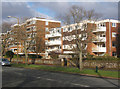
Apartments on Grand Avenue, Worthing
Langham Court is the larger block in the background.
Image: © Andrew Hill
Taken: 26 Jan 2009
0.03 miles
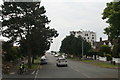
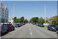
3
Grand Avenue
Looking South towards the sea down this impressive West Worthing avenue.
Image: © Chris Shaw
Taken: 14 Jun 2005
0.14 miles
4
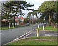
Grand Avenue, Worthing
Looking across the end of Lansdowne Road. The traffic lights at the crossing of Mill Road (A259) can be seen in the distance.
Image: © Andrew Hill
Taken: 26 Jan 2009
0.15 miles
5
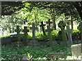
Heene Cemetery
Taken from the locked entrance gates
Image: © Josie Campbell
Taken: 9 May 2011
0.17 miles
6
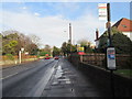
Bus stop Mill Road (A259)
For Stagecoach services 9, 700 and Pulse.
Image: © Peter Holmes
Taken: 13 Feb 2015
0.22 miles
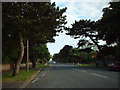
7
Grand Avenue, Worthing
A broad tree-lined thoroughfare heading inland from West Parade towards West Worthing station.
Image: © Stephen McKay
Taken: 1 Jun 2017
0.25 miles