IMAGES TAKEN NEAR TO
Tarring Road, WORTHING, BN11 4HB
Introduction
This page details the photographs taken nearby to Tarring Road, BN11 4HB by members of the Geograph project.
The Geograph project started in 2005 with the aim of publishing, organising and preserving representative images for every square kilometre of Great Britain, Ireland and the Isle of Man.

There are currently over 7.5m images from over14,400 individuals and you can help contribute to the project by visiting https://www.geograph.org.uk
Image Map
Images are licensed for reuse under creativecommons.org/licenses/by-sa/2.0
Notes
- Clicking on the map will re-center to the selected point.
- The higher the marker number, the further away the image location is from the centre of the postcode.
Image Listing (125 Images Found)
Images are licensed for reuse under creativecommons.org/licenses/by-sa/2.0
Image
Details
Distance
1
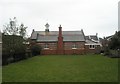
Grassed area adjacent to St Matthew's Church Hall
Image: © Basher Eyre
Taken: 16 Feb 2010
0.00 miles
3
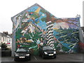
Splendid mural in Tarring Road
On the house next to St Matthew's Church hall.
Image: © Basher Eyre
Taken: 16 Feb 2010
0.02 miles
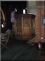
4
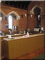
Kitchen area within St Matthew's, Worthing
Image: © Basher Eyre
Taken: 16 Feb 2010
0.02 miles
5
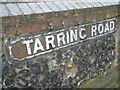
Old fashioned road sign outside St Matthew's, Worthing
Image: © Basher Eyre
Taken: 16 Feb 2010
0.02 miles
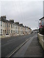
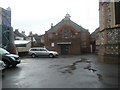
6

Approaching St Matthew's, Worthing
Taken in Tarring Road.
Image: © Basher Eyre
Taken: 16 Feb 2010
0.02 miles
7
St Matthew's Church Hall in Tarring Road
Image: © Basher Eyre
Taken: 16 Feb 2010
0.02 miles
10
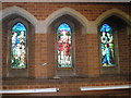
Stained glass windows on the south wall at St Matthew's, Worthing
Image: © Basher Eyre
Taken: 16 Feb 2010
0.02 miles