IMAGES TAKEN NEAR TO
The Linkway, Howard Street, WORTHING, BN11 4EJ
Introduction
This page details the photographs taken nearby to The Linkway, Howard Street, BN11 4EJ by members of the Geograph project.
The Geograph project started in 2005 with the aim of publishing, organising and preserving representative images for every square kilometre of Great Britain, Ireland and the Isle of Man.

There are currently over 7.5m images from over14,400 individuals and you can help contribute to the project by visiting https://www.geograph.org.uk
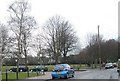
Image Map
Images are licensed for reuse under creativecommons.org/licenses/by-sa/2.0
Notes
- Clicking on the map will re-center to the selected point.
- The higher the marker number, the further away the image location is from the centre of the postcode.
Image Listing (184 Images Found)
Images are licensed for reuse under creativecommons.org/licenses/by-sa/2.0
Image
Details
Distance
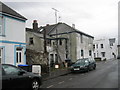
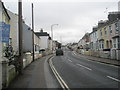
2
Junction of Norfolk Street and St Matthew's Road
Image: © Basher Eyre
Taken: 16 Feb 2010
0.03 miles
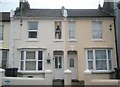
4
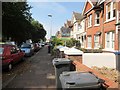
St Matthews Road BN11 4AU
Mainly split into flats.
Image: © Peter Holmes
Taken: 13 Sep 2016
0.04 miles
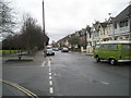
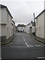
5
Approaching the junction of Anglesea Street, Norfolk Street and St Matthew's Road
Image: © Basher Eyre
Taken: 16 Feb 2010
0.04 miles
6
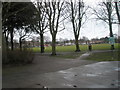
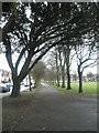
Late winter in the recreation ground in St Matthew's Road
Image: © Basher Eyre
Taken: 16 Feb 2010
0.05 miles
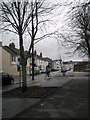
7
Approaching the junction of Anglesea Street and London Street
Image: © Basher Eyre
Taken: 16 Feb 2010
0.05 miles
8
'Cat' sitting at the 'window' in Teville Road
Image: © Basher Eyre
Taken: 16 Feb 2010
0.05 miles
10
Looking from Teville Road into Orme Road
Image: © Basher Eyre
Taken: 16 Feb 2010
0.06 miles