IMAGES TAKEN NEAR TO
Shelley Road, WORTHING, BN11 4DA
Introduction
This page details the photographs taken nearby to Shelley Road, BN11 4DA by members of the Geograph project.
The Geograph project started in 2005 with the aim of publishing, organising and preserving representative images for every square kilometre of Great Britain, Ireland and the Isle of Man.

There are currently over 7.5m images from over14,400 individuals and you can help contribute to the project by visiting https://www.geograph.org.uk
Image Map
Images are licensed for reuse under creativecommons.org/licenses/by-sa/2.0
Notes
- Clicking on the map will re-center to the selected point.
- The higher the marker number, the further away the image location is from the centre of the postcode.
Image Listing (217 Images Found)
Images are licensed for reuse under creativecommons.org/licenses/by-sa/2.0
Image
Details
Distance
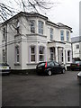
2
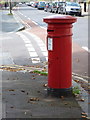
Worthing: postbox № BN11 1633, Shelley Road
A Victorian box on the corner of Eriswell Road, emptied finally at 5:45pm on weekdays and at 12:15pm on Saturdays.
Image: © Chris Downer
Taken: 24 Sep 2011
0.05 miles


9
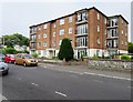
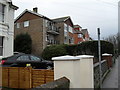
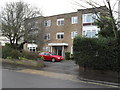
Cranleigh Court, Byron Road, BN11 3HR
Block of modern flats.
Image: © Peter Holmes
Taken: 20 Jul 2016
0.06 miles
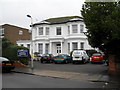
10
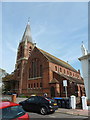
Worthing: Holy Trinity church
An attractive red-brick church on the corner of Shelley Road and Eriswell Road, across which latter we look.
Image: © Chris Downer
Taken: 24 Sep 2011
0.06 miles