IMAGES TAKEN NEAR TO
Ophir Road, WORTHING, BN11 2ST
Introduction
This page details the photographs taken nearby to Ophir Road, BN11 2ST by members of the Geograph project.
The Geograph project started in 2005 with the aim of publishing, organising and preserving representative images for every square kilometre of Great Britain, Ireland and the Isle of Man.

There are currently over 7.5m images from over14,400 individuals and you can help contribute to the project by visiting https://www.geograph.org.uk
Image Map
Images are licensed for reuse under creativecommons.org/licenses/by-sa/2.0
Notes
- Clicking on the map will re-center to the selected point.
- The higher the marker number, the further away the image location is from the centre of the postcode.
Image Listing (192 Images Found)
Images are licensed for reuse under creativecommons.org/licenses/by-sa/2.0
Image
Details
Distance
1
Looking from Heatherstone Road into Malvern Close
Image: © Basher Eyre
Taken: 18 Jul 2010
0.04 miles
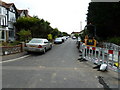
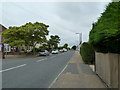
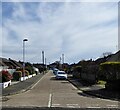
2
Approaching the junction of Heatherstone Road and Malvern Close
Image: © Basher Eyre
Taken: 18 Jul 2010
0.05 miles
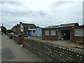
4
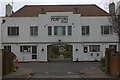
Pearson's Retreat
Entrance to Pearson's and St Elizabeth's cottage homes. Retirement homes.
Image: © Robert Eva
Taken: 7 Mar 2020
0.08 miles
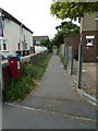
9
Benedict Drive, Worthing
A residential road linking Meadow Road to Brougham Road built in the 1950s on the site of a nursery called Parramatta Vineries.
Image: © Simon Carey
Taken: 31 Mar 2024
0.10 miles
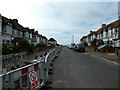
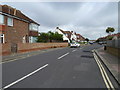
10
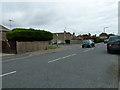
Approaching the junction of Brougham Road and Benedict Drive
Image: © Basher Eyre
Taken: 18 Jul 2010
0.10 miles