IMAGES TAKEN NEAR TO
Farncombe Road, WORTHING, BN11 2BE
Introduction
This page details the photographs taken nearby to Farncombe Road, BN11 2BE by members of the Geograph project.
The Geograph project started in 2005 with the aim of publishing, organising and preserving representative images for every square kilometre of Great Britain, Ireland and the Isle of Man.

There are currently over 7.5m images from over14,400 individuals and you can help contribute to the project by visiting https://www.geograph.org.uk
Image Map
Images are licensed for reuse under creativecommons.org/licenses/by-sa/2.0
Notes
- Clicking on the map will re-center to the selected point.
- The higher the marker number, the further away the image location is from the centre of the postcode.
Image Listing (145 Images Found)
Images are licensed for reuse under creativecommons.org/licenses/by-sa/2.0
Image
Details
Distance
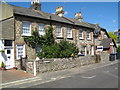
1
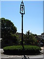
Farncombe Road / Church Walk Lamp Post
When electricity came to Worthing in 1901, the borough council installed 110 elaborate cast-iron lamp-posts with hexagonal glass and iron lamps suspended from an arm 20 feet (6.1 m) above the ground. The only remaining example saved by Worthing Civic Society founder Patricia Baring, outside whose home it stood is on a traffic island at the Farncombe Road Church Walk junction.
The lamp-post is a Grade II listed building.
Image: © Josie Campbell
Taken: 1 Jul 2011
0.03 miles
2
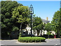
Listed Lamp Standard junction Farncombe Road and Church Walk
When electricity came to Worthing in 1901, the borough council installed 110 elaborate cast-iron lamp-posts with hexagonal glass and iron lamps suspended from an arm 20 feet (6.1 m) above the ground. The only remaining example saved by Worthing Civic Society founder Patricia Baring, outside whose home it stood is on a floral-planted traffic island.
Listed as a Grade II Building
Image: © Josie Campbell
Taken: 1 Jul 2011
0.03 miles
3
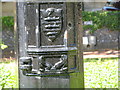
Town Shield on Lamp Post, Farncombe Road / Church Walk
Worthing's shield on the Lamp Post.
Image: © Josie Campbell
Taken: 1 Jul 2011
0.03 miles
5
Church Cottages, Selden Lane, Worthing
This small terrace appears to have been two cottages when built in the early 19th century, but three cottages now occupy it. The walls are of large flints dressed and quoined with red brick, which also frames the sash windows. The roof is of slate and has three chimneys. It is a Grade II listed Building.
The two cottages at the end of the terrace with the porch must have been added later, they do not appear to be listed.
Listed separately as Grade II is the flint garden wall.
Image: © Josie Campbell
Taken: 1 Jul 2011
0.08 miles
6
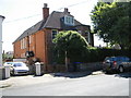
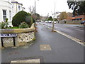
Selden Road, Worthing
In 1906 this site was chosen to build the Vicarage for St George's Church on. It remained a Vicarage until 2006 when it was put up for sale, and sold in 2009.
Image: © Josie Campbell
Taken: 1 Jul 2011
0.09 miles
8
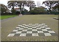
Chess Board, Beach House Park, Worthing
Image: © Paul Gillett
Taken: 20 Oct 2014
0.11 miles
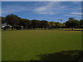
9
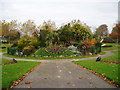
Beach House Park, Ornamental Garden
There is a memorial to wartime carrier pigeons on this mound with a metal plaque to the north side with the following inscription:-
"On top of this mound is a memorial to warrior birds who gave their lives on active service 1939-45. It is also for the pleasure & use of living birds."
Image: © Peter Holmes
Taken: 6 Nov 2007
0.12 miles
10
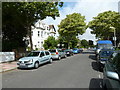
Approaching the crossroads of St George's Road and Church Walk
Image: © Basher Eyre
Taken: 18 Jul 2010
0.12 miles