IMAGES TAKEN NEAR TO
Teville Road, WORTHING, BN11 1UH
Introduction
This page details the photographs taken nearby to Teville Road, BN11 1UH by members of the Geograph project.
The Geograph project started in 2005 with the aim of publishing, organising and preserving representative images for every square kilometre of Great Britain, Ireland and the Isle of Man.

There are currently over 7.5m images from over14,400 individuals and you can help contribute to the project by visiting https://www.geograph.org.uk
Image Map
Images are licensed for reuse under creativecommons.org/licenses/by-sa/2.0
Notes
- Clicking on the map will re-center to the selected point.
- The higher the marker number, the further away the image location is from the centre of the postcode.
Image Listing (243 Images Found)
Images are licensed for reuse under creativecommons.org/licenses/by-sa/2.0
Image
Details
Distance
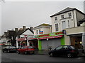
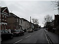
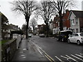
2
Approaching the junction of Teville Road and Christchurch Road
Image: © Basher Eyre
Taken: 16 Feb 2010
0.01 miles
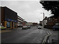
7
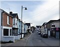
Oxford Road, Worthing
A residential road that runs from railway Approach in the north, crosses Teville Road, the A2031, then continues southwards to Cambridge Road. This is the part to the north of the A2031 developed in the 1880s.
Image: © Simon Carey
Taken: 31 Mar 2024
0.04 miles
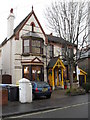
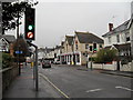
10
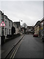
Looking down Oxford Road towards Teville Road
Image: © Basher Eyre
Taken: 16 Feb 2010
0.05 miles