IMAGES TAKEN NEAR TO
Teville Road, WORTHING, BN11 1UF
Introduction
This page details the photographs taken nearby to Teville Road, BN11 1UF by members of the Geograph project.
The Geograph project started in 2005 with the aim of publishing, organising and preserving representative images for every square kilometre of Great Britain, Ireland and the Isle of Man.

There are currently over 7.5m images from over14,400 individuals and you can help contribute to the project by visiting https://www.geograph.org.uk
Image Map
Images are licensed for reuse under creativecommons.org/licenses/by-sa/2.0
Notes
- Clicking on the map will re-center to the selected point.
- The higher the marker number, the further away the image location is from the centre of the postcode.
Image Listing (319 Images Found)
Images are licensed for reuse under creativecommons.org/licenses/by-sa/2.0
Image
Details
Distance
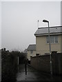
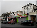
4
Route to Railway Station
Run-down area awaiting development.
Image: © Peter Holmes
Taken: 3 Mar 2015
0.05 miles
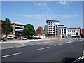
5
Teville Gate, Worthing
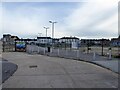
Historically the area was a former common that was located to the north of Teville Stream whose current course lies culverrted underneath this site. When the current A24 was opened as a turnpike in 1803 a tollhouse, known as Teville Gate, was placed at the point where the current junction with Teville Road is located. With the arrival of the railway the turnpikes were closed and a new road, Railway Approach was built across the site along with gradual development of the northern side of Teville Road. In the late 1960s all was swept away when a new shopping centre and multi-storey car park was built as a new gateway to Worthing. However, the development dated rapidly and many businesses left the area with the last to go in 2017 after which the retail units were demolished. The multi-storey car park and offices followed in 2018. Plans for new developments have often stalled though it now appears from 2024 the brownfield site will be solely devoted to building homes.
The houses in the distance are on the southern side of Teville Road, the A2031.
Image: © Simon Carey
Taken: 31 Mar 2024
0.06 miles
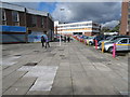
7
Approaching the junction of Teville Road and Christchurch Road
Image: © Basher Eyre
Taken: 16 Feb 2010
0.06 miles
10
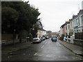
Looking from Wenban Road into Hertford Road
Image: © Basher Eyre
Taken: 16 Feb 2010
0.06 miles