IMAGES TAKEN NEAR TO
Graham Road, WORTHING, BN11 1TL
Introduction
This page details the photographs taken nearby to Graham Road, BN11 1TL by members of the Geograph project.
The Geograph project started in 2005 with the aim of publishing, organising and preserving representative images for every square kilometre of Great Britain, Ireland and the Isle of Man.

There are currently over 7.5m images from over14,400 individuals and you can help contribute to the project by visiting https://www.geograph.org.uk
Image Map
Images are licensed for reuse under creativecommons.org/licenses/by-sa/2.0
Notes
- Clicking on the map will re-center to the selected point.
- The higher the marker number, the further away the image location is from the centre of the postcode.
Image Listing (477 Images Found)
Images are licensed for reuse under creativecommons.org/licenses/by-sa/2.0
Image
Details
Distance
1
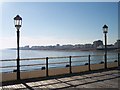
Worthing Beach from the pier.
Looking north west. The Lido is visible on the right.
Image: © Bob Embleton
Taken: 30 Aug 2005
0.01 miles
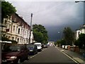
2
T Junction Christchurch Rd and Richmond Rd
Storm clouds gathering over Worthing
Image: © Steve Lee
Taken: 19 Aug 2005
0.01 miles
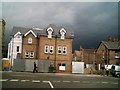
4
Worthing Community Programme in Crescent Road
Image: © Basher Eyre
Taken: 16 Feb 2010
0.01 miles
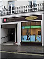
6
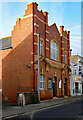
Worthing : Salvation Army citadel
Built in 1912 to a design by Oswald Archer, architect to the Salvation Army.
(Worthing Gazette - Wednesday 03 April 1912, p. 3)
Image: © Jim Osley
Taken: 10 Feb 2022
0.01 miles