IMAGES TAKEN NEAR TO
Liverpool Gardens, WORTHING, BN11 1SD
Introduction
This page details the photographs taken nearby to Liverpool Gardens, BN11 1SD by members of the Geograph project.
The Geograph project started in 2005 with the aim of publishing, organising and preserving representative images for every square kilometre of Great Britain, Ireland and the Isle of Man.

There are currently over 7.5m images from over14,400 individuals and you can help contribute to the project by visiting https://www.geograph.org.uk
Image Map
Images are licensed for reuse under creativecommons.org/licenses/by-sa/2.0
Notes
- Clicking on the map will re-center to the selected point.
- The higher the marker number, the further away the image location is from the centre of the postcode.
Image Listing (540 Images Found)
Images are licensed for reuse under creativecommons.org/licenses/by-sa/2.0
Image
Details
Distance
1
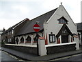
Worthing Spiritualist Church in Grafton Road
Image: © Basher Eyre
Taken: 16 Feb 2010
0.01 miles
3
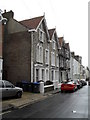
Scaffolding on a house in Portland Road
Image: © Basher Eyre
Taken: 16 Feb 2010
0.01 miles
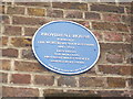
6
Former Ebenezer Chapel, Portland Road, Worthing
1907 on the stone tablet, also informing it was a Calvinistic Strict Baptist chapel. Now apparently a house.
Image: © Robin Webster
Taken: 29 Dec 2022
0.02 miles
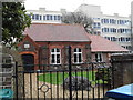
8
Approaching the junction of Portland Road and Ambrose Place
Image: © Basher Eyre
Taken: 16 Feb 2010
0.02 miles
9
Looking from Ambrose Place into Field Row
Image: © Basher Eyre
Taken: 16 Feb 2010
0.03 miles
