IMAGES TAKEN NEAR TO
Charlecote Road, WORTHING, BN11 1LX
Introduction
This page details the photographs taken nearby to Charlecote Road, BN11 1LX by members of the Geograph project.
The Geograph project started in 2005 with the aim of publishing, organising and preserving representative images for every square kilometre of Great Britain, Ireland and the Isle of Man.

There are currently over 7.5m images from over14,400 individuals and you can help contribute to the project by visiting https://www.geograph.org.uk
Image Map
Images are licensed for reuse under creativecommons.org/licenses/by-sa/2.0
Notes
- Clicking on the map will re-center to the selected point.
- The higher the marker number, the further away the image location is from the centre of the postcode.
Image Listing (315 Images Found)
Images are licensed for reuse under creativecommons.org/licenses/by-sa/2.0
Image
Details
Distance
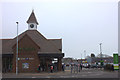
1
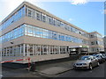
Crown House, Worthing Job Centre
Charlecote Road entrance.
Image: © Peter Holmes
Taken: 3 Mar 2015
0.02 miles
3
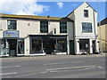
High Street
Older properties in the High Street including Lavenda the only Polish Restaurant in town.
Image: © Peter Holmes
Taken: 3 Mar 2015
0.05 miles
4
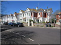
Elm Road, BN11 1PG
Larger Victorian houses mostly divided into flats.
Image: © Peter Holmes
Taken: 21 Apr 2015
0.06 miles
6
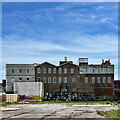
Rear of buildings on Chatsworth Road
That looks like a big pile of air-con units stacked up at the rear of the building.
Image: © Ian Hawfinch
Taken: 28 Apr 2023
0.06 miles
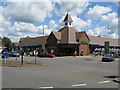
7
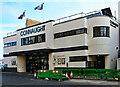
Worthing : Connaught Cinema
Built as The Picturedrome in 1913-1914, the "Moderne" styling to the frontage dates from 1933. More at this http://cinematreasures.org/theaters/23914.
Image: © Jim Osley
Taken: 10 Feb 2022
0.07 miles
8
Worthing, Ten
Cocktail bar and restaurant at 10 High Street; old OS maps confirm it as a former church. https://licklist.co.uk/ten-cocktail-bar?fbclid=IwAR2cdecL8MGr7Gq6wuViOmBZrPtncUwxgSkvCDxcXUwsWSE0ZaCIsaHTaps
Image: © Mike Faherty
Taken: 1 Dec 2018
0.08 miles
9
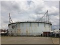
Worthing Gas Holder
Built on the site of the old gas works in Lyndhurst Road Worthing. The gas works closed in 1931 and the gas holder was built in 1934. The gas holder is now redundant and land is being considered for residential and retail development.
Image: © Donald Simmons
Taken: 11 Jun 2016
0.08 miles
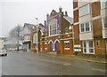
10
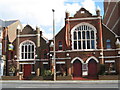
High Street, Worthing
St James Evangelical Free Church was registered for worship in 1926 and closed in 1988. It then became a cafe bar called 'The Church' (in name only it was nothing to do with a church) as in this photo. It has been taken over a few times and has had different names.
Image: © Josie Campbell
Taken: 8 Mar 2007
0.09 miles