IMAGES TAKEN NEAR TO
Newland Street, WORTHING, BN11 1JU
Introduction
This page details the photographs taken nearby to Newland Street, BN11 1JU by members of the Geograph project.
The Geograph project started in 2005 with the aim of publishing, organising and preserving representative images for every square kilometre of Great Britain, Ireland and the Isle of Man.

There are currently over 7.5m images from over14,400 individuals and you can help contribute to the project by visiting https://www.geograph.org.uk
Image Map
Images are licensed for reuse under creativecommons.org/licenses/by-sa/2.0
Notes
- Clicking on the map will re-center to the selected point.
- The higher the marker number, the further away the image location is from the centre of the postcode.
Image Listing (138 Images Found)
Images are licensed for reuse under creativecommons.org/licenses/by-sa/2.0
Image
Details
Distance
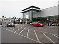
1

Newland Street, Worthing
A residential street linking Newland Road to Station Road along with entrance to Morissons. The supermarket is built on the site of Worthing's former goods yard that closed in 1970.
Image: © Simon Carey
Taken: 31 Mar 2024
0.01 miles
2
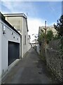
The Old Stables, Station Road, Worthing
A view of the rear of the former stables converted into flats.
Image: © Simon Carey
Taken: 31 Mar 2024
0.02 miles
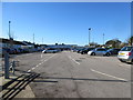
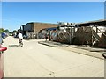
3
Morrisons, Newland Street
Superstore with provision for cycle parking.
Image: © Peter Holmes
Taken: 10 Feb 2015
0.04 miles
5
Wenban-Smith, Newland Road
Established in 1876 offering a vast range of timber and timber related products, everything from screws to spiral staircases.
Image: © Peter Holmes
Taken: 10 Feb 2015
0.07 miles
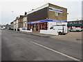
6
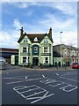
The Toad in the Hole, Newland Road, Worthing
Built in 1873 on the corner of what was the western entrance to Station Road which was closed when the supermarked to the rear was built in the 1990s on the site of the old goods yard. Opened as the Castle Hotel it has also been the Castle Alehouse, O'Connors Bar, Tap and Tankard, acquiring its current name when a local craft brewery took on the premises.
Image: © Simon Carey
Taken: 31 Mar 2024
0.07 miles
7
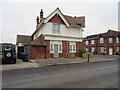
Residential development, Newland Road
Previously The Globe public house which closed on 29th October 2009.
Image: © Peter Holmes
Taken: 10 Feb 2015
0.07 miles
8
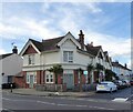
73, Newland Road, Worthing
The current block of flats located on the corner of Dagmar Street and newland Road was once The Globe public house, first opened in 1866, then rebuilt in the 1900s. It closed in 2013.
Image: © Simon Carey
Taken: 31 Mar 2024
0.07 miles
9

Terraced housing in Stanley Road
Victorian properties built in the 1870/80s for middle-class professionals.
Image: © Peter Holmes
Taken: 10 Feb 2015
0.07 miles
10
Ivy Arch Road, BN14 8BX
Gardner & Scardifield supplier of building materials.
Image: © Peter Holmes
Taken: 30 Aug 2016
0.07 miles