IMAGES TAKEN NEAR TO
Ashdown Road, WORTHING, BN11 1DF
Introduction
This page details the photographs taken nearby to Ashdown Road, BN11 1DF by members of the Geograph project.
The Geograph project started in 2005 with the aim of publishing, organising and preserving representative images for every square kilometre of Great Britain, Ireland and the Isle of Man.

There are currently over 7.5m images from over14,400 individuals and you can help contribute to the project by visiting https://www.geograph.org.uk
Image Map
Images are licensed for reuse under creativecommons.org/licenses/by-sa/2.0
Notes
- Clicking on the map will re-center to the selected point.
- The higher the marker number, the further away the image location is from the centre of the postcode.
Image Listing (297 Images Found)
Images are licensed for reuse under creativecommons.org/licenses/by-sa/2.0
Image
Details
Distance
2
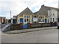
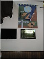
Ashdown Road Playgroup and Ashdown Centre
Flint capped building presented with "Distinction in building award" in 1999 by Worthing Borough Council.
Image: © Peter Holmes
Taken: 24 Feb 2015
0.03 miles
3
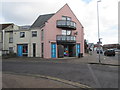
Pink Bathstore
In North Street (A259) at junction with Ashdown Road.
Image: © Peter Holmes
Taken: 24 Feb 2015
0.04 miles
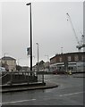
7
Looking towards an underpass in Chapel Road
Image: © Basher Eyre
Taken: 16 Feb 2010
0.07 miles