IMAGES TAKEN NEAR TO
Outlook Avenue, PEACEHAVEN, BN10 8XE
Introduction
This page details the photographs taken nearby to Outlook Avenue, BN10 8XE by members of the Geograph project.
The Geograph project started in 2005 with the aim of publishing, organising and preserving representative images for every square kilometre of Great Britain, Ireland and the Isle of Man.

There are currently over 7.5m images from over14,400 individuals and you can help contribute to the project by visiting https://www.geograph.org.uk
Image Map
Images are licensed for reuse under creativecommons.org/licenses/by-sa/2.0
Notes
- Clicking on the map will re-center to the selected point.
- The higher the marker number, the further away the image location is from the centre of the postcode.
Image Listing (22 Images Found)
Images are licensed for reuse under creativecommons.org/licenses/by-sa/2.0
Image
Details
Distance
1
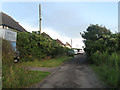
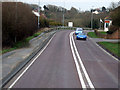
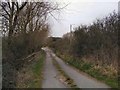
Outlook Avenue
Part of the original 1920s layout for Peacehaven Heights. The road runs in a straight line from South Coast Road, the A259, and The Highway and is a little more developed than neighbouring Image The three houses on the left were built in the 1930s.
Image: © Simon Carey
Taken: 6 Jul 2012
0.03 miles
2
Blakeney Avenue Peacehaven Heights
One of several unadopted roads in the area.
Image: © Dave Spicer
Taken: 12 Aug 2012
0.07 miles
3
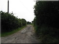
Chene Road
Part of the original 1920s Peacehaven Heights layout the road links South Coast Road, the A259, with The Highway. Like most of the Heights take up for plots was slow from the beginning with only two occupied by 1928 and three by 1938 whereupon tougher planning laws were bought in after the Second World War with just one another residence added from that point on. To give an idea of how many plots were expected to be sold along the road, the visible roof belongs to number 28, two other numbered properties are 8 and 12. Another house was originally built at the junction with the A259, on the right, but was demolished in the early 1980s. The road remains unmade and single track and probably not the best place to test out whether you can go up to national speed limit travelling along it.
Image: © Simon Carey
Taken: 6 Jul 2012
0.09 miles
4
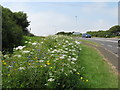
Wildflower planting by the A259
Makes a change from the normal grass verge.
Image: © Dave Spicer
Taken: 12 Aug 2012
0.11 miles
5
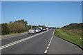
South Coast Road traffic queue
A tailback caused by the raising of bridge over the River Ouse at Newhaven Harbour Image
Image: © Oast House Archive
Taken: 10 Oct 2010
0.14 miles
6
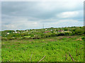
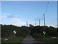
Cleared land, Peacehaven Heights
Or rather an attempt to clear this plot of land of gorse and bracken by the owners for possible sale. However, the job is half complete as the roots are deep. The roof of Peacehaven Golf Course Club House is straight ahead. The tower is a TV communications mast.
Image: © Simon Carey
Taken: 1 Jun 2006
0.15 miles
8
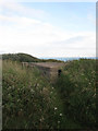
Former Gun Emplacement (1), Rushy Hill
One of two surviving shelters in the vicinity that belonged to 3.7in Heavy Anti Aircraft guns set up to guard a nearby World War Two radar station on the cliff tops. Two others now lie under Rushy Hill Caravan Park.See also Image and Image
Image: © Simon Carey
Taken: 6 Jul 2012
0.16 miles
9
Maple Road
Path off the A259 Brighton Road, between Peacehaven and Newhaven
Image: © Paul Gillett
Taken: 17 Mar 2010
0.17 miles
10
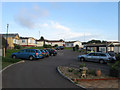
Tudor Rose Caravan Park
A caravan park has existed on the site since the 1960s and is currently for static caravans inhabited by retired or semi retired people.
Image: © Simon Carey
Taken: 6 Jul 2012
0.18 miles