IMAGES TAKEN NEAR TO
Steyning Avenue, PEACEHAVEN, BN10 8LU
Introduction
This page details the photographs taken nearby to Steyning Avenue, BN10 8LU by members of the Geograph project.
The Geograph project started in 2005 with the aim of publishing, organising and preserving representative images for every square kilometre of Great Britain, Ireland and the Isle of Man.

There are currently over 7.5m images from over14,400 individuals and you can help contribute to the project by visiting https://www.geograph.org.uk
Image Map
Images are licensed for reuse under creativecommons.org/licenses/by-sa/2.0
Notes
- Clicking on the map will re-center to the selected point.
- The higher the marker number, the further away the image location is from the centre of the postcode.
Image Listing (124 Images Found)
Images are licensed for reuse under creativecommons.org/licenses/by-sa/2.0
Image
Details
Distance
1
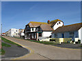
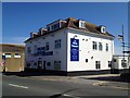
Dewdrop Inn, Steyning Avenue
Opened in 1924 as a tearoom before conversion to a pub four years later which it has been ever since. The small bungalow to the right is a dental surgery whilst to the left in the distance is a small parade of shops on the corner of Steyning Avenue and South Coast Road.
Image: © Simon Carey
Taken: 15 Mar 2009
0.01 miles
2
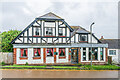
The Dewdrop Inn
Pub in Steyning Avenue originally built in 1924 as a tearoom and shop and then licensed in 1928
Image: © Ian Capper
Taken: 21 May 2024
0.02 miles
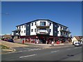
3
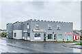
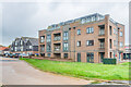
Evelyn Court
Castellated mixed use building on South Coast Road.
Image: © Ian Capper
Taken: 21 May 2024
0.05 miles
5
The White Schooner public house, Peacehaven
Image: © Stacey Harris
Taken: 19 Jun 2012
0.06 miles
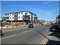
6
21 Steyning Avenue
Apartment block on the corner of Steyning Avenue and South Coast Road, converted in c.2016 from a previous two storey commercial block.
Image: © Ian Capper
Taken: 21 May 2024
0.07 miles
7
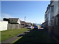
Bramber Avenue
Looking north from The Promenade where the road heads towards the A259 before continuing onwards to Arundel Road. Separated from its northern section by the Meridian Industrial Estate. The house on the right is a nursing home.
Image: © Simon Carey
Taken: 15 Mar 2009
0.07 miles
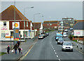
10
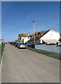
South Coast Road, Peacehaven
South Coast Road is on the route of the A259 as it passes through Peacehaven on the Sussex coast.
Image: © Malc McDonald
Taken: 24 Jul 2022
0.09 miles