IMAGES TAKEN NEAR TO
Albany Drive, BURY, BL9 9RD
Introduction
This page details the photographs taken nearby to Albany Drive, BL9 9RD by members of the Geograph project.
The Geograph project started in 2005 with the aim of publishing, organising and preserving representative images for every square kilometre of Great Britain, Ireland and the Isle of Man.

There are currently over 7.5m images from over14,400 individuals and you can help contribute to the project by visiting https://www.geograph.org.uk
Image Map
Images are licensed for reuse under creativecommons.org/licenses/by-sa/2.0
Notes
- Clicking on the map will re-center to the selected point.
- The higher the marker number, the further away the image location is from the centre of the postcode.
Image Listing (58 Images Found)
Images are licensed for reuse under creativecommons.org/licenses/by-sa/2.0
Image
Details
Distance
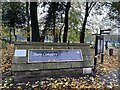
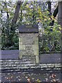
1
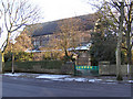
Location of OS Cut Mark - Bury, Bury Cemetery Wall
Image: © thejackrustles
Taken: 3 Nov 2021
0.05 miles
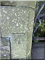
2
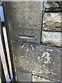
OS Cut Mark - Bury, Bury Cemetery Wall
https://www.bench-marks.org.uk/bm105595
Image: © thejackrustles
Taken: 3 Nov 2021
0.05 miles
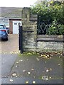
3
Location of OS Cut Mark - Bury, Bury Cemetery Wall
Image: © thejackrustles
Taken: 3 Nov 2021
0.08 miles
4
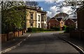
Heaton Court
Heaton Grove House on Heaton Court in Bury.
From the Manchester Evening News:
Heaton Grove was built around 1840 for Thomas Heaton who was Governor of Redvales Workhouse. It later passed to Richard Hacking, a local JP who died in 1862 when it was put up for auction. Subsequent famous owners included Thomas Lomax Openshaw and builder James Byrom. William Whewhell was the last occupant, a man famous for breeding Shire horses. His animals, all with the prefix Heaton, won over 1,000 first prizes and hundreds of championship awards. He was awarded the MBE for services for the conservation of the gentle giants.
When the house fell empty various schemes were put forward and a Manchester business man wanted to pull it down and develop the site with houses. Local people objected and various arguments rumbled on about the grade two listed building and its future. Early in 1988 a fierce blaze all but gutted Heaton Grove and the property developer faced rebuilding it, even though it had almost been demolished. In 1995 Fairclough Homes applied to build homes but locals were against this and demanded that the Palladian fronted building should be restored to its former glory. Local civic crusader Munroe Hall campaigned to have it rebuilt and converted into flats but there were still complaints about access. Eventually a compromise was reached to turn the hall into flats and build some houses in the grounds. Now a new access road has been created and 16 detached homes have also been built in the grounds. The final scheme included the preservation of trees ensuring that the original outlook of the Grove will remain much as it has been for many years.
Image: © Peter McDermott
Taken: 23 Apr 2017
0.08 miles
5
OS Cut Mark - Bury, Bury Cemetery Wall
https://www.bench-marks.org.uk/bm105596
Image: © thejackrustles
Taken: 3 Nov 2021
0.09 miles
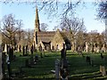
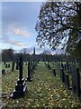
7
St Peter's Church
Large, Anglican church dating from 1872.
Image: © David Dixon
Taken: 31 Jan 2010
0.11 miles
8
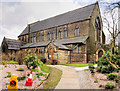
Bury, The Church of St Peter
Large, Anglican church dating from 1872.
Image: © David Dixon
Taken: 6 Apr 2016
0.11 miles