IMAGES TAKEN NEAR TO
Vale Avenue, BURY, BL9 9LW
Introduction
This page details the photographs taken nearby to Vale Avenue, BL9 9LW by members of the Geograph project.
The Geograph project started in 2005 with the aim of publishing, organising and preserving representative images for every square kilometre of Great Britain, Ireland and the Isle of Man.

There are currently over 7.5m images from over14,400 individuals and you can help contribute to the project by visiting https://www.geograph.org.uk
Image Map (Loading...)


Getting Data...Please wait
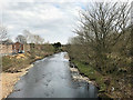
Leaflet Map data © OpenStreetMap
Images are licensed for reuse under creativecommons.org/licenses/by-sa/2.0
Notes
- Clicking on the map will re-center to the selected point.
- The higher the marker number, the further away the image location is from the centre of the postcode.
Image Listing (49 Images Found)
Images are licensed for reuse under creativecommons.org/licenses/by-sa/2.0
Image
Details
Distance
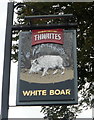
3

The "White Boar" Radcliffe Road, Bury
Image: © Alexander P Kapp
Taken: 13 Aug 2007
0.07 miles
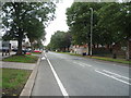
5

Radcliffe Road Baptist Church
For those of you that like a description - it's on ... err ... Radcliffe Road.
Image: © JThomas
Taken: 10 Sep 2018
0.09 miles
6
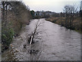
River Irwell, downstream from Warth Bridge
Looking downstream from Warth Bridge. The River Irwell has been swollen by recent heavy rainfall and is considerably higher (and wider) than usual.
Image: © David Dixon
Taken: 31 Dec 2012
0.14 miles
7
River Irwell
Looking downstream from Warth Bridge.
Image: © David Dixon
Taken: 4 Apr 2020
0.14 miles
8
River Irwell, Warth
The river, just downstream from Warth Bridge.
Image: © David Dixon
Taken: 6 Mar 2012
0.14 miles
9
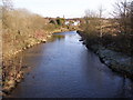
River Irwell
The River Irwell, downstream after it has passed Warth Mills and under Radcliffe Road at Warth Bridge.
Image: © David Dixon
Taken: 31 Jan 2010
0.15 miles
10
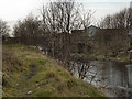
Sluice Gate, Bealey's Goit
This derelict sluice gate is between the River Irwell and Bealey's Goit, an artificial channel constructed to supply water from the river for the Bealey's bleachworks in Radcliffe.
Image: © David Dixon
Taken: 6 Mar 2012
0.16 miles