IMAGES TAKEN NEAR TO
Back Parkhills Road South, BURY, BL9 9AY
Introduction
This page details the photographs taken nearby to Back Parkhills Road South, BL9 9AY by members of the Geograph project.
The Geograph project started in 2005 with the aim of publishing, organising and preserving representative images for every square kilometre of Great Britain, Ireland and the Isle of Man.

There are currently over 7.5m images from over14,400 individuals and you can help contribute to the project by visiting https://www.geograph.org.uk
Image Map
Images are licensed for reuse under creativecommons.org/licenses/by-sa/2.0
Notes
- Clicking on the map will re-center to the selected point.
- The higher the marker number, the further away the image location is from the centre of the postcode.
Image Listing (86 Images Found)
Images are licensed for reuse under creativecommons.org/licenses/by-sa/2.0
Image
Details
Distance
1
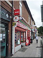
Post Office on Parkhills Road, Bury
Showing position of Postbox No. BL9 74.
See Image] for postbox.
Image: © JThomas
Taken: 10 Sep 2018
0.01 miles
2
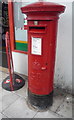
George V postbox on Parkhills Road, Bury
Outside the Post Office.
Postbox No. BL9 74.
See Image] for context.
Image: © JThomas
Taken: 10 Sep 2018
0.02 miles
4
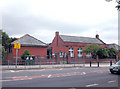
Fishpool Infants School Bury
This school, completed just before WW2 used to have an underground air raid shelter beneath the playground. The school was designed around a quadrangle which was the playground. There were classrooms on two sides with the school hall and head teacher's office on the third side. The toilets were on the fourth side of the playground. The classrooms and the school hall had verandahs on the playground side.
Image: © Dennis Turner
Taken: 22 Jul 2005
0.03 miles
5
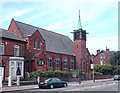
Bethesda Pentecostal Church Parkhills
The former Parkhills Methodist Church. At the junction of Horne Street and Parkhills Road.
Image: © Dennis Turner
Taken: 22 Jul 2005
0.03 miles
6
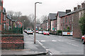
Horne Street Fishpool
A typical street in the area.
Image: © Dennis Turner
Taken: 21 Jan 2003
0.03 miles
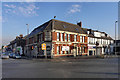
7
The former Pack Horse Hotel, Bury
On Manchester Road (A56).
Now converted to shops.
Image: © JThomas
Taken: 10 Sep 2018
0.04 miles
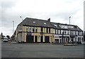
8
Pack Horse Hotel
A large pub/hotel (currently closed) at the junction of Parkhills Road and Manchester Road (A56), in the Fishpool area of Bury.
Image: © David Dixon
Taken: 17 Jan 2012
0.04 miles
9
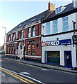
Former Pack Horse Hotel, Bury
Viewed across Heaton Fold. Located next door to a Betfred,
the former Pack Horse Hotel is on the corner of Parkhills Road.
Image: © Jaggery
Taken: 6 Oct 2013
0.04 miles
10
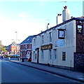
Staff of Life, Bury
The Staff of Life at 211-215 Manchester Road is the nearest pub to the Gigg Lane ground of Bury Football Club.
Image: © Jaggery
Taken: 6 Oct 2013
0.05 miles