IMAGES TAKEN NEAR TO
Pilsworth Way, BURY, BL9 8RE
Introduction
This page details the photographs taken nearby to Pilsworth Way, BL9 8RE by members of the Geograph project.
The Geograph project started in 2005 with the aim of publishing, organising and preserving representative images for every square kilometre of Great Britain, Ireland and the Isle of Man.

There are currently over 7.5m images from over14,400 individuals and you can help contribute to the project by visiting https://www.geograph.org.uk
Image Map (Loading...)


Getting Data...Please wait
Leaflet Map data © OpenStreetMap
Images are licensed for reuse under creativecommons.org/licenses/by-sa/2.0
Notes
- Clicking on the map will re-center to the selected point.
- The higher the marker number, the further away the image location is from the centre of the postcode.
Image Listing (11 Images Found)
Images are licensed for reuse under creativecommons.org/licenses/by-sa/2.0
Image
Details
Distance
4
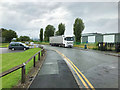
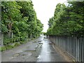
Croft Lane towards the M66 Motorway
Looking north east.
Image: © JThomas
Taken: 10 Sep 2018
0.14 miles
5
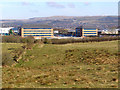
Castlebrook Business Park
Looking towards the Castlebrook business park on Pilsworth Road, from Hollins Lane.
Image: © David Dixon
Taken: 9 Mar 2010
0.16 miles
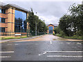
7
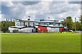
Bury Gymnastics Centre
Part of Bury's Goshen Sports Centre. The new £1.95 million state-of-the-art centre at Goshen opened in 2012. It includes the new gymnastics centre, improved football changing rooms and a community room. Nearly half of the original centre in Tennyson Avenue was destroyed and £100,000 worth of sports equipment wrecked by a fire in 2007.
https://www.burytimes.co.uk/news/9852487.gymnastics-club-rises-from-the-ashes/ (Bury Times 7 August 2012).
Image: © David Dixon
Taken: 17 May 2021
0.17 miles
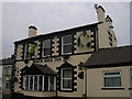
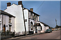
8
The former Roach Bank public house
On Croft Lane.
Image: © JThomas
Taken: 10 Sep 2018
0.18 miles
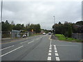
9
Aviation Way
Used as a bridleway to access Hollins Vale Local Nature Reserve from Pilsworth Road
Image: © Kevin Waterhouse
Taken: 15 Jun 2024
0.19 miles
10
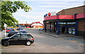
The front entrance of the bowling alley
One of the main attractions in Park 66 at Pilsworth.
Image: © Bill Boaden
Taken: 29 Jun 2010
0.22 miles