IMAGES TAKEN NEAR TO
Pilsworth Cottages, BURY, BL9 8QW
Introduction
This page details the photographs taken nearby to Pilsworth Cottages, BL9 8QW by members of the Geograph project.
The Geograph project started in 2005 with the aim of publishing, organising and preserving representative images for every square kilometre of Great Britain, Ireland and the Isle of Man.

There are currently over 7.5m images from over14,400 individuals and you can help contribute to the project by visiting https://www.geograph.org.uk
Image Map (Loading...)


Getting Data...Please wait
Leaflet Map data © OpenStreetMap
Images are licensed for reuse under creativecommons.org/licenses/by-sa/2.0
Notes
- Clicking on the map will re-center to the selected point.
- The higher the marker number, the further away the image location is from the centre of the postcode.
Image Listing (15 Images Found)
Images are licensed for reuse under creativecommons.org/licenses/by-sa/2.0
Image
Details
Distance
1
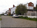
Pilsworth Cottages
A row of three cottages at the end of Castle Road.
Image: © David Dixon
Taken: 3 May 2012
0.01 miles
2
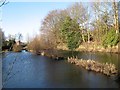
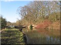
Compartment reservoir
Water bodies along the Brightley Brook are remnants of the industrial past, whose earliest record is Morris's Mill (Fustian) in the 1851 OS Map, by which time these reservoirs were extant. The site was subsequently developed into Pilsworth Bleach Works which were recorded in the 1894 edition. The segregation into neat compartments was not fully recorded and cannot be explained. Nowadays the water bodies are managed by the Pilsworth Fishery, and are delightful, though not fully accessible by the public.
Image: © Jonathan Wilkins
Taken: 25 Feb 2018
0.06 miles
3
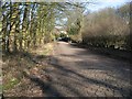
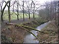
Castle Road
The wonderful paving of Castle Road as it descends from the eponymous property towards the site of Pilsworth Bleach Works. People are standing at the much corroded iron bridge over the Whittle Brook. The sense of history in this area is inescapable.
Image: © Jonathan Wilkins
Taken: 25 Feb 2018
0.07 miles
4
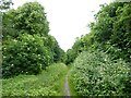
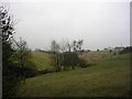
Overgrown bridleway
Heading towards the former Pilsworth Bleach Works site but without any views of the former reservoirs that served the works
Image: © Kevin Waterhouse
Taken: 15 Jun 2024
0.10 miles
5
Hollins Brook
Looking downstream from the bridge on Castle Road, between Unsworth and Pilsworth. A bleach works once stood on the right bank at this point (shown on the 1940's OS map)
Image: © Keith Williamson
Taken: 18 Jan 2006
0.11 miles
6
Hollins Brook
Looking upstream from the Castle Road bridge between Unsworth and Pilsworth. Upstream of this point Hollins Brook is known as Whittle Brook.
Image: © Keith Williamson
Taken: 18 Jan 2006
0.11 miles
7
Eastern reservoir
Further water storage areas on the level to the east of Pilsworth Bleach Works.
See Image for further information.
Image: © Jonathan Wilkins
Taken: 25 Feb 2018
0.16 miles
9
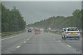
Hollins : M66 Motorway
Looking along the M66.
Image: © Lewis Clarke
Taken: 27 Sep 2019
0.18 miles
10
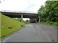
M66 motorway viaduct
Across Aviation Road near the former Pilsworth Bleach Works
Image: © Kevin Waterhouse
Taken: 15 Jun 2024
0.18 miles