IMAGES TAKEN NEAR TO
Castle Road, BURY, BL9 8QS
Introduction
This page details the photographs taken nearby to Castle Road, BL9 8QS by members of the Geograph project.
The Geograph project started in 2005 with the aim of publishing, organising and preserving representative images for every square kilometre of Great Britain, Ireland and the Isle of Man.

There are currently over 7.5m images from over14,400 individuals and you can help contribute to the project by visiting https://www.geograph.org.uk
Image Map (Loading...)


Getting Data...Please wait
Leaflet Map data © OpenStreetMap
Images are licensed for reuse under creativecommons.org/licenses/by-sa/2.0
Notes
- Clicking on the map will re-center to the selected point.
- The higher the marker number, the further away the image location is from the centre of the postcode.
Image Listing (8 Images Found)
Images are licensed for reuse under creativecommons.org/licenses/by-sa/2.0
Image
Details
Distance
1
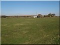
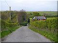
Thurston Fold
Looking over farmland to Thurston Fold. The distant horizon shows the raised profile of Pilsworth Quarry landfill before the distant hills and wind turbines take control. This is a strange enclave, cut off from the world by motorways and a protected green belt area.
Image: © Jonathan Wilkins
Taken: 25 Feb 2018
0.02 miles
4
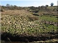
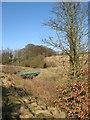
Meandering Whittle Brook
Abandoned, tussocky pasture adjacent to the Whittle Brook, which meanders spectacularly in this valley which it occupies.
Image: © Jonathan Wilkins
Taken: 25 Feb 2018
0.11 miles
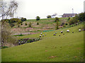
5
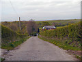
Bridge, Whittle Brook
A well-maintained bridge carrying a footpath to Higher Barn and Moss Hall Road.
Image: © Jonathan Wilkins
Taken: 25 Feb 2018
0.18 miles
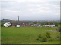
8
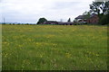
Brick House Farm
It doesn't show up well, but Scout Moor Wind Farm is visible on the skyline to the left.
Image: © Bill Boaden
Taken: 12 Jun 2012
0.24 miles