IMAGES TAKEN NEAR TO
Alkrington Close, BURY, BL9 8NP
Introduction
This page details the photographs taken nearby to Alkrington Close, BL9 8NP by members of the Geograph project.
The Geograph project started in 2005 with the aim of publishing, organising and preserving representative images for every square kilometre of Great Britain, Ireland and the Isle of Man.

There are currently over 7.5m images from over14,400 individuals and you can help contribute to the project by visiting https://www.geograph.org.uk
Image Map (Loading...)


Getting Data...Please wait
Leaflet Map data © OpenStreetMap
Images are licensed for reuse under creativecommons.org/licenses/by-sa/2.0
Notes
- Clicking on the map will re-center to the selected point.
- The higher the marker number, the further away the image location is from the centre of the postcode.
Image Listing (7 Images Found)
Images are licensed for reuse under creativecommons.org/licenses/by-sa/2.0
Image
Details
Distance
1
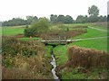
Parr Brook
Footbridge in Sunny Bank Wood, Bury. The bridge (in SD8106) crosses Parr Brook.
Image: © Keith Williamson
Taken: 12 Oct 2005
0.13 miles
2
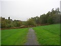
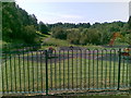
Sunny Bank Wood
Looking in a north westerly direction in Sunny Bank Wood, Bury - not many trees here! SD81460703.
Image: © Keith Williamson
Taken: 12 Oct 2005
0.15 miles
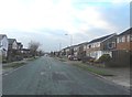

5
Cunningham Drive, Whitefield
Looking northeast. Typical housing development within this square that was once home to several cotton mills.
Image: © Keith Williamson
Taken: 18 Jan 2006
0.22 miles
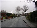
7
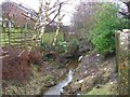
Parr Brook
Looking downstream. The brook here runs behind the houses on Cunningham Drive, Whitefield. The 1940's OS map shows that this area was once home to a number of cotton mills, now long gone.
Image: © Keith Williamson
Taken: 18 Jan 2006
0.24 miles