IMAGES TAKEN NEAR TO
Bleasdale Close, BURY, BL9 8EW
Introduction
This page details the photographs taken nearby to Bleasdale Close, BL9 8EW by members of the Geograph project.
The Geograph project started in 2005 with the aim of publishing, organising and preserving representative images for every square kilometre of Great Britain, Ireland and the Isle of Man.

There are currently over 7.5m images from over14,400 individuals and you can help contribute to the project by visiting https://www.geograph.org.uk
Image Map
Images are licensed for reuse under creativecommons.org/licenses/by-sa/2.0
Notes
- Clicking on the map will re-center to the selected point.
- The higher the marker number, the further away the image location is from the centre of the postcode.
Image Listing (9 Images Found)
Images are licensed for reuse under creativecommons.org/licenses/by-sa/2.0
Image
Details
Distance
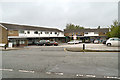
1
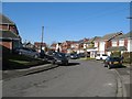
Linksway Drive
Part of a housing estate at Sunny Bank.
Image: © Jonathan Wilkins
Taken: 25 Feb 2018
0.03 miles
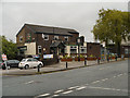
2
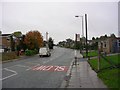
Sunny Bank Road
Looking east along Sunny Bank Road, Bury. SD81520719.
Image: © Keith Williamson
Taken: 12 Oct 2005
0.12 miles
4
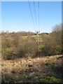
Pylon line
Power lines and pylons crossing the Parr Brook and golf course towards Unsworth.
Image: © Jonathan Wilkins
Taken: 25 Feb 2018
0.16 miles
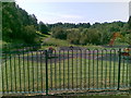
5
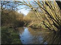
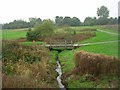
Parr Brook
A weir on the Parr Brook in woodland which separates Sunny Bank from the Bury Golf Club.
Image: © Jonathan Wilkins
Taken: 25 Feb 2018
0.20 miles
6
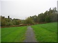
Sunny Bank Wood
Looking in a north westerly direction in Sunny Bank Wood, Bury - not many trees here! SD81460703.
Image: © Keith Williamson
Taken: 12 Oct 2005
0.22 miles
9
Parr Brook
Footbridge in Sunny Bank Wood, Bury. The bridge (in SD8106) crosses Parr Brook.
Image: © Keith Williamson
Taken: 12 Oct 2005
0.24 miles